
Topografische Karte Limpsfield Chart
Klicken Sie auf die Karte, um die Höhe anzuzeigen.
Über diese Karte
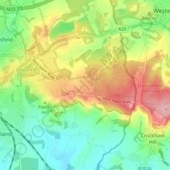
Name: Topografische Karte Limpsfield Chart, Höhe, Relief.
Durchschnittliche Höhe: 126 m
Minimale Höhe: 66 m
Maximale Höhe: 214 m
Andere topografische Karten
Klicken Sie auf eine Karte, um ihre Topografie, ihre Höhe und ihr Relief anzuzeigen.
Warlingham
United Kingdom > England > Surrey > Tandridge
Elevations vary from 110m AOD at Woldingham Road, at the southernmost point of the parish, with a gentle increase in height through the village along the main road heading to the southeast, to the highest elevation (199.6m) at Limpsfield Road.
Durchschnittliche Höhe: 163 m