
Topografische Karte Yongfu County
Interaktive Karte
Klicken Sie auf die Karte, um die Höhe anzuzeigen.
Yongfu County
Yongfu County (Chinese: 永福县; pinyin: Yǒngfú Xiàn) is a county under the administration of the prefecture-level city of Guilin, Guangxi, China, located 55 km (34 mi) to the southwest of downtown Guilin. The county is mostly rural and hilly, marked by the same dramatic karst topography for which Guilin is famous.
Über diese Karte
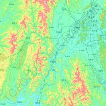
Name: Topografische Karte Yongfu County, Höhe, Relief.
Ort: Yongfu County, Guilin, Guangxi, China (24.64826 109.61164 25.44246 110.23691)
Durchschnittliche Höhe: 344 m
Minimale Höhe: 101 m
Maximale Höhe: 1.361 m