
Topografische Karte Sines
Interaktive Karte
Klicken Sie auf die Karte, um die Höhe anzuzeigen.
Über diese Karte
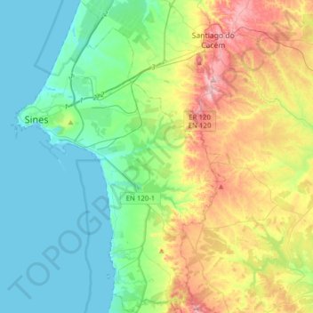
Name: Topografische Karte Sines, Höhe, Relief.
Ort: Sines, Setúbal, Portugal (37.80495 -8.89392 38.04929 -8.68144)
Durchschnittliche Höhe: 85 m
Minimale Höhe: 0 m
Maximale Höhe: 291 m
Andere topografische Karten
Klicken Sie auf eine Karte, um ihre Topografie, ihre Höhe und ihr Relief anzuzeigen.
Cercal
Portugal > Setúbal > Santiago do Cacém
Cercal, Santiago do Cacém, Setúbal, 7555-254, Portugal
Durchschnittliche Höhe: 202 m
Forte de São Domingos da Baralha
Forte de São Domingos da Baralha, Ruínas Chã dos Navegantes, Sesimbra (Castelo), Sesimbra, Setúbal, 2970-085, Portugal
Durchschnittliche Höhe: 51 m
Cercal do Alentejo
Cercal do Alentejo, Cercal, Santiago do Cacém, Setúbal, 7555-254, Portugal
Durchschnittliche Höhe: 166 m
Santiago do Cacém
Portugal > Setúbal > Santiago do Cacém, Santa Cruz e São Bartolomeu da Serra > Santiago do Cacém
Santiago do Cacém, Santiago do Cacém, Santa Cruz e São Bartolomeu da Serra, Santiago do Cacém, Setúbal, Alentejo, 7540-148, Portugal
Durchschnittliche Höhe: 166 m
Cercal do Alentejo
Portugal > Setúbal > Cercal do Alentejo
Cercal do Alentejo, Santiago do Cacém, Setúbal, Alentejo, Portugal
Durchschnittliche Höhe: 135 m
Santiago do Cacém
Santiago do Cacém, Setúbal, Portugal
Durchschnittliche Höhe: 116 m
Porto Covo
Portugal > Setúbal > Porto Covo
Porto Covo, Sines, Setúbal, Alentejo, Portugal
Durchschnittliche Höhe: 36 m
Costa da Caparica
Costa da Caparica, Almada, Setúbal, Portugal
Durchschnittliche Höhe: 21 m