
Vielen Dank für die Unterstützung dieser Website ❤️
Spenden
Spenden
Topografische Karte Vinhedo
Klicken Sie auf die Karte, um die Höhe anzuzeigen.
Vielen Dank für die Unterstützung dieser Website ❤️
Spenden
Spenden
Vinhedo
Vinhedo (Portuguese pronunciation: [viˈɲedu]) is a municipality in the state of São Paulo in Brazil. It is part of the Metropolitan Region of Campinas. The population in 2020 was 80,111 and its area is 81.60 km2 (31.51 sq mi). It has a population density of 981 inhabitants per square kilometer. The elevation is 777 m (2,549 ft). Vinhedo is 96% urbanized and It was founded in 1949.
Vielen Dank für die Unterstützung dieser Website ❤️
Spenden
Spenden
Über diese Karte
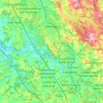
Name: Topografische Karte Vinhedo, Höhe, Relief.
Durchschnittliche Höhe: 735 m
Minimale Höhe: 623 m
Maximale Höhe: 981 m
Vielen Dank für die Unterstützung dieser Website ❤️
Spenden
Spenden
Andere topografische Karten
Klicken Sie auf eine Karte, um ihre Topografie, ihre Höhe und ihr Relief anzuzeigen.
João Aranha
Brazil > São Paulo > Região Metropolitana de Campinas > Paulínia
Durchschnittliche Höhe: 583 m