
Topografische Karte Kill Devil Hills
Interaktive Karte
Klicken Sie auf die Karte, um die Höhe anzuzeigen.
Kill Devil Hills
First Flight Airport covers an area of 40 acres at an elevation of 13 feet (4 metres) above mean sea level. It has one runway; designated 2/20, with an asphalt surface measuring 3,000 by 60 feet (914 by 18 metres). For the 12-month period ending August 19, 2009, the airport had 38,120 aircraft operations, an average of 104 per day: 97% general aviation, 3% air taxi, and <1% military.
Über diese Karte
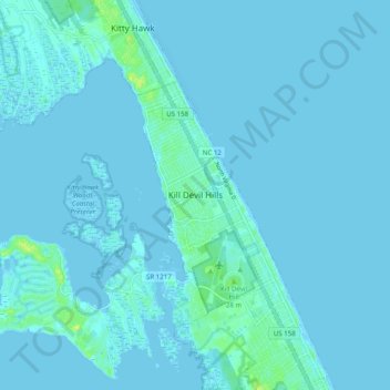
Name: Topografische Karte Kill Devil Hills, Höhe, Relief.
Durchschnittliche Höhe: 1 m
Minimale Höhe: -4 m
Maximale Höhe: 15 m