
Topografische Karte Makkah Al Mukarramah
Interaktive Karte
Klicken Sie auf die Karte, um die Höhe anzuzeigen.
Über diese Karte
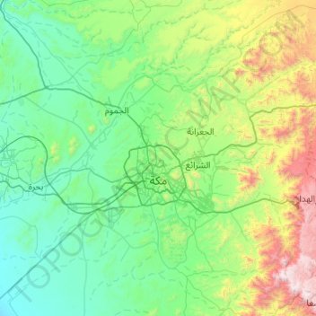
Name: Topografische Karte Makkah Al Mukarramah, Höhe, Relief.
Ort: Makkah Al Mukarramah, Makkah Region, Saudi Arabia (21.11982 39.50586 21.84804 40.47561)
Durchschnittliche Höhe: 479 m
Minimale Höhe: 18 m
Maximale Höhe: 2.588 m
Mecca is located in the Hejaz region, a 200 km (124 mi) wide strip of mountains separating the Nafud desert from the Red Sea. The city is situated in a valley with the same name around 70 km (44 mi) west of the port city of Jeddah. Mecca is one of the lowest cities in elevation in the Hejaz region, located at an elevation of 277 m (909 ft) above sea level at 21º23' north latitude and 39º51' east longitude. Mecca is divided into 34 districts.
Andere topografische Karten
Klicken Sie auf eine Karte, um ihre Topografie, ihre Höhe und ihr Relief anzuzeigen.
Jeddah
Jeddah, Governorate of Jidda, Makkah Region, 23434, Saudi Arabia
Durchschnittliche Höhe: 35 m
Al Lith
Al Lith, Makkah Region, Saudi Arabia
Durchschnittliche Höhe: 346 m
Rabigh
Rabigh, Makkah Region, 23955, Saudi Arabia
Durchschnittliche Höhe: 145 m
Governorate of Jidda
Governorate of Jidda, Makkah Region, Saudi Arabia
Durchschnittliche Höhe: 130 m
الباب
الباب, Khulays, Makkah Region, Saudi Arabia
Durchschnittliche Höhe: 886 m