
Spenden
Topografische Karte Piracicaba
Klicken Sie auf die Karte, um die Höhe anzuzeigen.
Spenden
Piracicaba
The terrain of Piracicaba is predominantly rugged, with a notable depression in the central part of its territory. This depression extends along the east-west course of the Piracicaba River, becoming more pronounced within the urban area at the river's waterfall. This region separates the watersheds of the Piracicaba and Tietê rivers. Valleys converging toward the Tietê River in the southwest and the Piracicaba River in the central region trend north-northwest, creating more pronounced depressions in these areas. The lowest elevations are approximately 420 meters, while the highest average around 780 meters. The average altitude of Piracicaba is 528 meters, situated in a significantly sloped area with an average slope of 7.8%.
Spenden
Über diese Karte
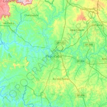
Name: Topografische Karte Piracicaba, Höhe, Relief.
Durchschnittliche Höhe: 570 m
Minimale Höhe: 450 m
Maximale Höhe: 1.062 m
Spenden
Andere topografische Karten
Klicken Sie auf eine Karte, um ihre Topografie, ihre Höhe und ihr Relief anzuzeigen.
Kobayat Líbano
Brazil > São Paulo > Região Metropolitana de Piracicaba > Piracicaba
Durchschnittliche Höhe: 521 m
Nova Piracicaba
Brazil > São Paulo > Região Metropolitana de Piracicaba > Piracicaba
Durchschnittliche Höhe: 493 m
Mirante Rio Piracicaba
Brazil > São Paulo > Região Metropolitana de Piracicaba > Piracicaba
Durchschnittliche Höhe: 505 m