
Topografische Karte Lake Placid
Interaktive Karte
Klicken Sie auf die Karte, um die Höhe anzuzeigen.
Über diese Karte
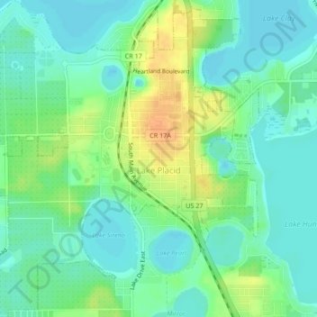
Name: Topografische Karte Lake Placid, Höhe, Relief.
Ort: Lake Placid, Highlands County, Florida, 33852, United States (27.27582 -81.39029 27.31301 -81.34960)
Durchschnittliche Höhe: 32 m
Minimale Höhe: 20 m
Maximale Höhe: 53 m
Andere topografische Karten
Klicken Sie auf eine Karte, um ihre Topografie, ihre Höhe und ihr Relief anzuzeigen.
Sebring
United States > Florida > Highlands County
Sebring, Highlands County, Florida, 33870, United States
Durchschnittliche Höhe: 34 m
Lake Huntley
United States > Florida > Highlands County
Lake Huntley, Highlands County, Florida, United States
Durchschnittliche Höhe: 30 m
Avon Park
United States > Florida > Highlands County
Avon Park, Highlands County, Florida, 33825, United States
Durchschnittliche Höhe: 43 m
Placid Lakes
United States > Florida > Highlands County
Placid Lakes, Highlands County, Florida, United States, Lake August
Durchschnittliche Höhe: 34 m
Placid Lakes
United States > Florida > Highlands County
Placid Lakes, Highlands County, Florida, United States
Durchschnittliche Höhe: 33 m
Lake Istokpoga
United States > Florida > Highlands County
Lake Istokpoga, Highlands County, Florida, United States
Durchschnittliche Höhe: 15 m
Sebring
United States > Florida > Highlands County > Sebring
Sebring, Highlands County, Florida, 33871, United States
Durchschnittliche Höhe: 36 m
Venus
United States > Florida > Highlands County
Venus, Highlands County, Florida, 33960, United States
Durchschnittliche Höhe: 33 m
Kuhlman
United States > Florida > Highlands County > Kuhlman
Kuhlman, Highlands County, Florida, 33872:33875, United States
Durchschnittliche Höhe: 29 m