
Spenden
Topografische Karte Carapungo
Klicken Sie auf die Karte, um die Höhe anzuzeigen.
Spenden
Über diese Karte
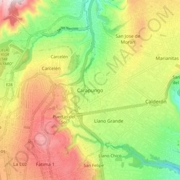
Name: Topografische Karte Carapungo, Höhe, Relief.
Durchschnittliche Höhe: 2.694 m
Minimale Höhe: 2.376 m
Maximale Höhe: 3.055 m
Spenden
Andere topografische Karten
Klicken Sie auf eine Karte, um ihre Topografie, ihre Höhe und ihr Relief anzuzeigen.
Spenden
Spenden
Cumbaya
At an elevation of 2200 m (7200 ft) above sea level, Cumbayá is lower than Quito and its climate is about 2 to 5 degrees Celsius warmer. Weather is semi tropical year-round, with a short rainy season.
Durchschnittliche Höhe: 2.444 m
Guayllabamba
Guayllabamba (Kichwa: Wayllapampa, "green plain") is a small agricultural town (administratively, a rural parish of the canton of Quito) located 29 kilometers northeast of the city of Quito in northern Ecuador. In the 2001 census, the parish had a population of 12,227. The elevation is 2,142 metres (7,028 ft)…
Durchschnittliche Höhe: 2.275 m
Spenden
Cumbaya
At an elevation of 2200 m (7200 ft) above sea level, Cumbayá is lower than Quito and its climate is about 2 to 5 degrees Celsius warmer. Weather is semi tropical year-round, with a short rainy season.
Durchschnittliche Höhe: 2.444 m
Spenden