
Topografische Karte Lindenwood
Interaktive Karte
Klicken Sie auf die Karte, um die Höhe anzuzeigen.
Über diese Karte
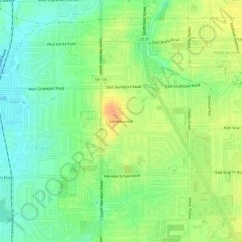
Name: Topografische Karte Lindenwood, Höhe, Relief.
Durchschnittliche Höhe: 227 m
Minimale Höhe: 210 m
Maximale Höhe: 246 m
Andere topografische Karten
Klicken Sie auf eine Karte, um ihre Topografie, ihre Höhe und ihr Relief anzuzeigen.
Eagle Creek Park
United States > Indiana > Marion County > Indianapolis
Eagle Creek Park, Indianapolis, Marion County, Indiana, 46253, United States
Durchschnittliche Höhe: 256 m
Fort Harrison State Park
United States > Indiana > Marion County > Indianapolis
Fort Harrison State Park, Indianapolis, Marion County, Indiana, United States
Durchschnittliche Höhe: 251 m
West Newton
United States > Indiana > Marion County > Indianapolis
West Newton, Indianapolis, Marion County, Indiana, 46183, United States
Durchschnittliche Höhe: 228 m
White River
United States > Indiana > Marion County > Indianapolis > Ravenswood
White River, Ravenswood, Indianapolis, Marion County, Indiana, 46240, United States
Durchschnittliche Höhe: 227 m
Wellington
United States > Indiana > Marion County > Indianapolis
Wellington, Indianapolis, Marion County, Indiana, 46220, United States
Durchschnittliche Höhe: 229 m
Maple Ridge
United States > Indiana > Marion County > Indianapolis
Maple Ridge, Indianapolis, Marion County, Indiana, 46183, United States
Durchschnittliche Höhe: 234 m
New Bethel
United States > Indiana > Marion County > Indianapolis
New Bethel, Indianapolis, Marion County, Indiana, 44623, United States
Durchschnittliche Höhe: 257 m
Legendary Hills
United States > Indiana > Marion County > Indianapolis
Legendary Hills, Indianapolis, Marion County, Indiana, 46278, United States
Durchschnittliche Höhe: 258 m
Drexel Gardens
United States > Indiana > Marion County > Indianapolis
Drexel Gardens, Indianapolis, Marion County, Indiana, 46241, United States
Durchschnittliche Höhe: 226 m
Sterling Heights
United States > Indiana > Marion County > Indianapolis > Sterling Heights
Sterling Heights, Indianapolis, Marion County, Indiana, 46251, United States
Durchschnittliche Höhe: 238 m
Glendale Heights
United States > Indiana > Marion County > Indianapolis
Glendale Heights, Indianapolis, Marion County, Indiana, 46220, United States
Durchschnittliche Höhe: 229 m
Newfields
United States > Indiana > Marion County > Indianapolis > Shooters Hill
Newfields, Shooters Hill, Indianapolis, Marion County, Indiana, 46208, United States
Durchschnittliche Höhe: 226 m