
Topografische Karte चितवन
Interaktive Karte
Klicken Sie auf die Karte, um die Höhe anzuzeigen.
Über diese Karte
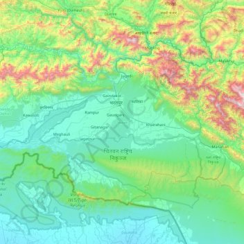
Name: Topografische Karte चितवन, Höhe, Relief.
Ort: चितवन, Provinz Bagmati, Nepal (27.35613 83.91936 27.88088 84.79637)
Durchschnittliche Höhe: 469 m
Minimale Höhe: 93 m
Maximale Höhe: 2.084 m
Andere topografische Karten
Klicken Sie auf eine Karte, um ihre Topografie, ihre Höhe und ihr Relief anzuzeigen.
Yala Peak
Nepal > Provinz Bagmati > Rasuwa
Yala Peak, Gosaikunda, Rasuwa, Provinz Bagmati, Nepal
Durchschnittliche Höhe: 5.200 m
Karthali
Nepal > Provinz Bagmati > सिन्धुपाल्चोक
Karthali, Barhabise, सिन्धुपाल्चोक, Provinz Bagmati, Nepal
Durchschnittliche Höhe: 1.581 m
Telkot
Nepal > Provinz Bagmati > भक्तपुर
Telkot, Changunarayan-06, चाँगुनारायण नगरपालिका, भक्तपुर, Provinz Bagmati, 44812, Nepal
Durchschnittliche Höhe: 1.469 m
Dumre
Nepal > Provinz Bagmati > Sindhuli
Dumre, Kamalamei, Sindhuli, Provinz Bagmati, Nepal
Durchschnittliche Höhe: 485 m
Nagarkot
Nepal > Provinz Bagmati > Kavrepalanchok
Nagarkot, Banepa, Kavrepalanchok, Provinz Bagmati, 44812, Nepal
Durchschnittliche Höhe: 1.886 m
Kathmandu
Nepal > Provinz Bagmati > काठमाडौं
Kathmandu, काठमाडौँ महानगरपालिका, काठमाडौं, Provinz Bagmati, 46000, Nepal
Durchschnittliche Höhe: 1.538 m
Naubise
Nepal > Provinz Bagmati > Dhading
Naubise, धुनिबेशी नगरपालिका, Dhading, Provinz Bagmati, Nepal
Durchschnittliche Höhe: 1.320 m
Bhaktapur
Nepal > Provinz Bagmati > भक्तपुर > Changunarayan
Bhaktapur, Changunarayan-05, Changunarayan, चाँगुनारायण नगरपालिका, भक्तपुर, Provinz Bagmati, 44800, Nepal
Durchschnittliche Höhe: 1.399 m