
Topografische Karte Le Blanc
Interaktive Karte
Klicken Sie auf die Karte, um die Höhe anzuzeigen.
Über diese Karte
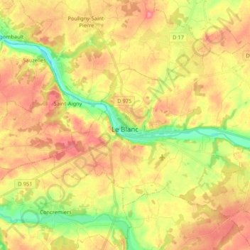
Name: Topografische Karte Le Blanc, Höhe, Relief.
Durchschnittliche Höhe: 111 m
Minimale Höhe: 69 m
Maximale Höhe: 144 m
Andere topografische Karten
Klicken Sie auf eine Karte, um ihre Topografie, ihre Höhe und ihr Relief anzuzeigen.
Buzançais
France > Centre-Val de Loire > Indre
Buzançais, Châteauroux, Indre, Centre-Val de Loire, France métropolitaine, 36500, France
Durchschnittliche Höhe: 130 m
Sainte-Sévère-sur-Indre
France > Centre-Val de Loire > Indre > Sainte-Sévère-sur-Indre
Sainte-Sévère-sur-Indre, La Châtre, Indre, Centre-Val de Loire, France métropolitaine, 36160, France
Durchschnittliche Höhe: 287 m
Saint-Christophe-en-Boucherie
France > Centre-Val de Loire > Indre > Saint-Christophe-en-Boucherie
Saint-Christophe-en-Boucherie, La Châtre, Indre, Centre-Val de Loire, France métropolitaine, 36400, France
Durchschnittliche Höhe: 237 m
Issoudun
France > Centre-Val de Loire > Indre > Issoudun
Issoudun, Indre, Centre-Val de Loire, France métropolitaine, 36100, France
Durchschnittliche Höhe: 149 m
Châteauroux
France > Centre-Val de Loire > Indre > Châteauroux
Châteauroux, Indre, Centre-Val de Loire, France métropolitaine, 36000, France
Durchschnittliche Höhe: 153 m
Éguzon-Chantôme
France > Centre-Val de Loire > Indre
Éguzon-Chantôme, Châteauroux, Indre, Centre-Val de Loire, France métropolitaine, 36270, France
Durchschnittliche Höhe: 264 m
Saint-Valentin
France > Centre-Val de Loire > Indre
Saint-Valentin, Issoudun, Indre, Centre-Val de Loire, France métropolitaine, 36100, France
Durchschnittliche Höhe: 164 m