
Spenden
Topografische Karte Santa Cruz
Klicken Sie auf die Karte, um die Höhe anzuzeigen.
Spenden
Santa Cruz
Santa Cruz is traversed by mountain ranges and high relief that include part of Mount Apo, the highest mountain peak in the Philippines, straddle the south, central, north and north-western portions of the municipality. The rugged topography of the central area gradually undulates toward the coastal plains of the north-eastern, eastern and south-eastern parts. Here, settlements sprawl contiguously along the coast of Davao Gulf under the vast monotony of coconut plantations. On the western frontier, a plateau stretches toward Barangay Kapatagan of Digos. The municipal elevation ranges from 10 to 2,939 metres (33 to 9,642 ft) above sea level (m.a.s.1.).
Spenden
Über diese Karte
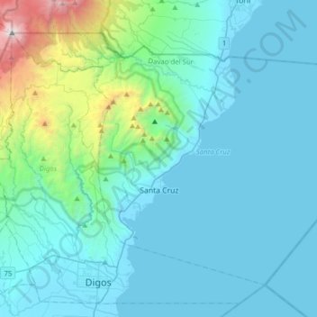
Name: Topografische Karte Santa Cruz, Höhe, Relief.
Ort: Santa Cruz, Davao del Sur, Davao Region, 8001, Philippines (6.74155 125.27078 6.98719 125.58180)
Durchschnittliche Höhe: 360 m
Minimale Höhe: -4 m
Maximale Höhe: 2.923 m
Spenden
Andere topografische Karten
Klicken Sie auf eine Karte, um ihre Topografie, ihre Höhe und ihr Relief anzuzeigen.
Digos
Philippines > Davao del Sur > Digos
The land topography of Digos City ranges from hilly to mountainous in the north-northeast portion and flat and slightly rolling at the coastal barangays, while the urban area and the surrounding barangays in the south portion are generally flat. Generally, climate in Digos falls under the fourth type while…
Durchschnittliche Höhe: 152 m
Spenden