
Topografische Karte Bearsbridge
Klicken Sie auf die Karte, um die Höhe anzuzeigen.
Über diese Karte
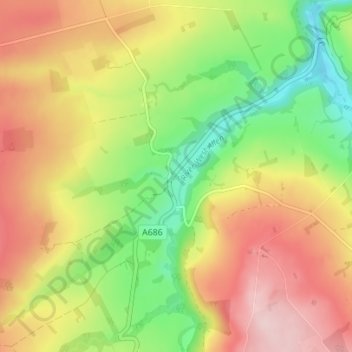
Name: Topografische Karte Bearsbridge, Höhe, Relief.
Durchschnittliche Höhe: 266 m
Minimale Höhe: 144 m
Maximale Höhe: 390 m
Andere topografische Karten
Klicken Sie auf eine Karte, um ihre Topografie, ihre Höhe und ihr Relief anzuzeigen.
Styford Wood
United Kingdom > England > Northumberland > Riding Mill > Bywell
Durchschnittliche Höhe: 64 m
Aydon Castle
United Kingdom > England > Northumberland > Corbridge > Aydon
Durchschnittliche Höhe: 121 m
Holy Island of Lindisfarne
United Kingdom > England > Northumberland > Holy Island
Durchschnittliche Höhe: 1 m
Berwick-upon-Tweed
United Kingdom > England > Northumberland
In the 1840s, Samuel Lewis included similar entries for Berwick-upon-Tweed in both his England and Scotland Topographical Dictionary. Berwick remained a county in its own right, and remained a separate parliamentary constituency until 1885 when it was merged to become a division of Northumberland under the…
Durchschnittliche Höhe: 33 m
North Hazelrigg
United Kingdom > England > Northumberland > Chatton > North Hazelrigg
Durchschnittliche Höhe: 99 m
Catcleugh Reservoir
United Kingdom > England > Northumberland
Catcleugh Reservoir is a reservoir in Northumberland, England, adjacent to the A68 road just north of Byrness and to the southeast of the border with Scotland. It has a surface area of 98.654 ha and a mean depth of 9.8 m, a catchment area of 4007.5 ha, and is situated at 247 m altitude.
Durchschnittliche Höhe: 316 m