
Topografische Karte Folsom
Interaktive Karte
Klicken Sie auf die Karte, um die Höhe anzuzeigen.
Über diese Karte
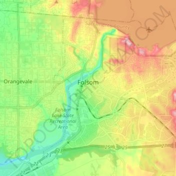
Name: Topografische Karte Folsom, Höhe, Relief.
Durchschnittliche Höhe: 92 m
Minimale Höhe: 21 m
Maximale Höhe: 186 m
Andere topografische Karten
Klicken Sie auf eine Karte, um ihre Topografie, ihre Höhe und ihr Relief anzuzeigen.
Elk Grove
États-Unis d'Amérique > Californie > Sacramento County
Elk Grove, Sacramento County, Californie, 95624, États-Unis d'Amérique
Durchschnittliche Höhe: 17 m
Sacramento
États-Unis d'Amérique > Californie > Sacramento County
Sacramento, Sacramento County, Californie, États-Unis d'Amérique
Durchschnittliche Höhe: 10 m
Sacramento
États-Unis d'Amérique > Californie > Sacramento County > Sacramento
Sacramento, Sacramento County, Californie, 95814, États-Unis d'Amérique
Durchschnittliche Höhe: 13 m
La Riviera
États-Unis d'Amérique > Californie > Sacramento County > Sacramento
La Riviera, Sacramento, Sacramento County, Californie, États-Unis d'Amérique
Durchschnittliche Höhe: 19 m