
Spenden
Topografische Karte Trevélez
Klicken Sie auf die Karte, um die Höhe anzuzeigen.
Spenden
Trevélez
The river Trevélez flows through the village, which lies at the confluence of the river with a smaller stream. It is divided into three parts, the Barrios Bajo, Medio and Alto (lower, mid and upper quarters), with 200 metres of altitude difference between the highest and lowest points. The only bridge over the river is in the Barrio Bajo.
Spenden
Über diese Karte
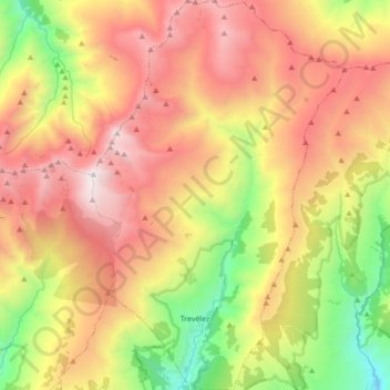
Name: Topografische Karte Trevélez, Höhe, Relief.
Durchschnittliche Höhe: 2.351 m
Minimale Höhe: 1.206 m
Maximale Höhe: 3.473 m
Spenden
Andere topografische Karten
Klicken Sie auf eine Karte, um ihre Topografie, ihre Höhe und ihr Relief anzuzeigen.
Cortijo ruinas
Spain > Andalusia > Comarca de la Alpujarra Granadina > Capileira
Durchschnittliche Höhe: 2.246 m
Laroles
Spain > Andalusia > Comarca de la Alpujarra Granadina > Nevada
Durchschnittliche Höhe: 1.028 m
Sierra Nevada
Spain > Andalusia > Comarca de la Alpujarra Granadina > Lanjarón
Durchschnittliche Höhe: 2.223 m
El Encinarillo
Spain > Andalusia > Comarca de la Alpujarra Granadina > Válor
Durchschnittliche Höhe: 1.717 m
Spenden
Pico de Mulhacén
Spain > Andalusia > Comarca de la Alpujarra Granadina > Trevélez
Mulhacén ([mulaˈθen]), with an elevation of 3,482 metres (11,424 ft), is the highest mountain in peninsular Spain and in all of the Iberian Peninsula. It is part of the Sierra Nevada range in the Penibaetic System. It is named after Abu'l-Hasan Ali, known as Muley Hacén in Spanish, the penultimate Muslim…
Durchschnittliche Höhe: 3.070 m
Pico del Veleta
Spain > Andalusia > Comarca de la Alpujarra Granadina > Capileira
The IRAM 30m telescope is located on the slopes of Pico Veleta, at an elevation of 2920 m.
Durchschnittliche Höhe: 2.998 m