
Spenden
Topografische Karte Muncho Lake
Klicken Sie auf die Karte, um die Höhe anzuzeigen.
Spenden
Muncho Lake
The lake is part of the Muncho Lake Provincial Park and located at kilometre 681 (mile 423) of the Alaska Highway. The lake is about 12 km (7.5 mi) long and its width varies. It reaches a maximum depth of 110 m (360 ft). The surrounding peaks (the Terminal Range of the Muskwa Ranges to the west and the Sentinel Range to the east) reach altitudes of more than 2,000 m (6,600 ft), while the lake lies at an elevation of 820 m (2,690 ft). It is formed along the Trout River, a tributary of the Liard River.
Spenden
Über diese Karte
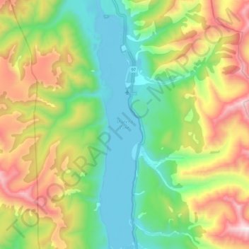
Name: Topografische Karte Muncho Lake, Höhe, Relief.
Durchschnittliche Höhe: 1.322 m
Minimale Höhe: 817 m
Maximale Höhe: 2.235 m
Spenden
Andere topografische Karten
Klicken Sie auf eine Karte, um ihre Topografie, ihre Höhe und ihr Relief anzuzeigen.
Fort Nelson
Canada > British Columbia > Northern Rockies Regional Municipality
Durchschnittliche Höhe: 405 m
Tetsa River
Canada > British Columbia > Northern Rockies Regional Municipality
Durchschnittliche Höhe: 1.610 m
Rocky Mountains
Canada > British Columbia > Northern Rockies Regional Municipality
Durchschnittliche Höhe: 1.329 m
Nelson Forks
Canada > British Columbia > Northern Rockies Regional Municipality
Durchschnittliche Höhe: 297 m
Spenden
Toad River
Canada > British Columbia > Northern Rockies Regional Municipality
Durchschnittliche Höhe: 831 m
Magnum Mine
Canada > British Columbia > Northern Rockies Regional Municipality
Durchschnittliche Höhe: 1.096 m
Fort Nelson
Canada > British Columbia > Northern Rockies Regional Municipality
Durchschnittliche Höhe: 404 m
Fort Nelson
Canada > British Columbia > Northern Rockies Regional Municipality
Durchschnittliche Höhe: 404 m
Spenden