Geolokalisieren
👉 Easily get elevation data in JSON, GeoTIFF and KML formats using Elevation API
Vielen Dank für die Unterstützung dieser Website ❤️
Spenden

Topografische Karte Coutances

Klicken Sie auf die Karte, um die Höhe anzuzeigen.

👉 Easily get elevation data in JSON, GeoTIFF and KML formats using Elevation API
Vielen Dank für die Unterstützung dieser Website ❤️
Spenden

Coutances

Coutances est située à l'ouest du Cotentin, à 12 km de la côte ouest. Le centre de la ville est situé sur un promontoire dont la cathédrale constitue le point culminant. En contrebas coule la Soulles, affluent du fleuve côtier la Sienne. La topographie de la ville lui a parfois valu le surnom de « Tolède du Cotentin ». L'agglomération est à 28 km à l'ouest de Saint-Lô, à 76 km au sud de Cherbourg-Octeville, à 88 km à l'ouest de Caen et à 127 km au nord de Rennes.

Wikipedia (CC-BY-SA 3.0)

👉 Easily get elevation data in JSON, GeoTIFF and KML formats using Elevation API
Vielen Dank für die Unterstützung dieser Website ❤️
Spenden

Über diese Karte

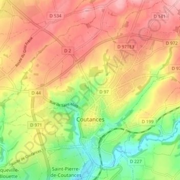
Name: Topografische Karte Coutances, Höhe, Relief.

Ort: Coutances, Manche, Normandie, France métropolitaine, 50200, France (49.03260 -1.48020 49.07780 -1.41000)

Durchschnittliche Höhe: 91 m

Minimale Höhe: 14 m

Maximale Höhe: 154 m

👉 Easily get elevation data in JSON, GeoTIFF and KML formats using Elevation API
Vielen Dank für die Unterstützung dieser Website ❤️
Spenden

Andere topografische Karten

Klicken Sie auf eine Karte, um ihre Topografie, ihre Höhe und ihr Relief anzuzeigen.

Saint-Martin de Bréhal

France > Normandie > Manche

Durchschnittliche Höhe: 5 m

Sommet dunes d'Hatainville

France > Normandie > Manche

Durchschnittliche Höhe: 35 m

Mont Castre

France > Normandie > Manche > Le Plessis-Lastelle

Le mont Castre, appelé aussi mont Castré, est une montagne du Massif armoricain. Elle est située dans le département de la Manche, sur les communes de Lithaire, du Plessis-Lastelle et de Gerville-la-Forêt. Il culmine à 130 m d'altitude. Chargé d'histoire, on y trouve des vestiges allant de la…

Durchschnittliche Höhe: 69 m

Hameau Burnel

France > Normandie > Manche > Cherbourg-en-Cotentin

Durchschnittliche Höhe: 61 m

Vielen Dank für die Unterstützung dieser Website ❤️
Spenden

Gonneville

France > Normandie > Manche > Blainville-sur-Mer

Durchschnittliche Höhe: 17 m

La Cauvinière

France > Normandie > Manche > Hébécrevon

Durchschnittliche Höhe: 59 m

Hameau Clapet

France > Normandie > Manche > Pierreville

Durchschnittliche Höhe: 75 m

Le Haut Candol

France > Normandie > Manche > Saint-Lô

Durchschnittliche Höhe: 48 m

Vielen Dank für die Unterstützung dieser Website ❤️
Spenden

Le Hameau Sauvage

France > Normandie > Manche > La Hague > Beaumont-Hague

Durchschnittliche Höhe: 131 m

La Fosserie

France > Normandie > Manche > Coutances

Durchschnittliche Höhe: 95 m

Hameau Gilles

France > Normandie > Manche > Anneville-en-Saire

Durchschnittliche Höhe: 9 m

Le Melleret

France > Normandie > Manche > Bricquebec-en-Cotentin > Bricquebec

Durchschnittliche Höhe: 57 m

Vielen Dank für die Unterstützung dieser Website ❤️
Spenden

Hameau du Cap Lévi

France > Normandie > Manche > Fermanville

Durchschnittliche Höhe: 15 m

La Mignarderie

France > Normandie > Manche > Cambernon

Durchschnittliche Höhe: 127 m

Les Hauts Vents

France > Normandie > Manche > Tessy-Bocage

Durchschnittliche Höhe: 104 m

La Brique

France > Normandie > Manche > Saint-Joseph

Durchschnittliche Höhe: 51 m

Vielen Dank für die Unterstützung dieser Website ❤️
Spenden

Les Moulins

France > Normandie > Manche > Barneville-Carteret

Durchschnittliche Höhe: 32 m

Le Hamel

France > Normandie > Manche > Condé-sur-Vire > Les Carrières

Durchschnittliche Höhe: 51 m

Les Grandies

France > Normandie > Manche > Sainte-Marie-du-Mont

Durchschnittliche Höhe: 7 m

La Jeannerie

France > Normandie > Manche > Blainville-sur-Mer

Durchschnittliche Höhe: 29 m

Vielen Dank für die Unterstützung dieser Website ❤️
Spenden

Le Haras

France > Normandie > Manche > Picauville

Durchschnittliche Höhe: 17 m

Hameau de Haut

France > Normandie > Manche > Les Moitiers-en-Bauptois

Durchschnittliche Höhe: 15 m

Le Hardelle

France > Normandie > Manche > Bretteville

Durchschnittliche Höhe: 50 m

Le Frechot

France > Normandie > Manche > Le Grand-Celland

Durchschnittliche Höhe: 177 m

Vielen Dank für die Unterstützung dieser Website ❤️
Spenden

Huanville

France > Normandie > Manche > Port-Bail-sur-Mer > Saint-Lô-d'Ourville

Durchschnittliche Höhe: 30 m

Manoir de Méterville

France > Normandie > Manche > Gorges > La Scellerie

Durchschnittliche Höhe: 13 m

Groussey

France > Normandie > Manche > Jullouville

Durchschnittliche Höhe: 45 m

La Bretonne

France > Normandie > Manche > Barfleur

Durchschnittliche Höhe: 6 m

Vielen Dank für die Unterstützung dieser Website ❤️
Spenden

Le Poiré

France > Normandie > Manche > Morville

Durchschnittliche Höhe: 30 m

Les Hauts Vents

France > Normandie > Manche > Bricqueville-sur-Mer

Durchschnittliche Höhe: 44 m

Le Hameau du Broquet

France > Normandie > Manche > Teurthéville-Bocage

Durchschnittliche Höhe: 69 m

Saint-Siméon

France > Normandie > Manche > Port-Bail-sur-Mer > Portbail

Durchschnittliche Höhe: 20 m

Vielen Dank für die Unterstützung dieser Website ❤️
Spenden

La Poterie

France > Normandie > Manche > Lengronne

Durchschnittliche Höhe: 97 m

Le Pont Gaché

France > Normandie > Manche > Gavray-sur-Sienne > Gavray

Durchschnittliche Höhe: 77 m

Le Saussey

France > Normandie > Manche > La Hague > Flottemanville-Hague

Durchschnittliche Höhe: 114 m

Mont Castre

France > Normandie > Manche > Montebourg

Durchschnittliche Höhe: 62 m

Vielen Dank für die Unterstützung dieser Website ❤️
Spenden

Hameau Commandé

France > Normandie > Manche > Flamanville

Durchschnittliche Höhe: 34 m

Les Noires Vaches

France > Normandie > Manche > Helleville

Durchschnittliche Höhe: 98 m

La Vincendière

France > Normandie > Manche > Vezins

Durchschnittliche Höhe: 93 m

La Groudière

France > Normandie > Manche > Le Mesnil-Garnier

Durchschnittliche Höhe: 141 m

Vielen Dank für die Unterstützung dieser Website ❤️
Spenden

Les Andrieux

France > Normandie > Manche > Airel

Durchschnittliche Höhe: 17 m

Goury

France > Normandie > Manche > La Hague > Auderville

Durchschnittliche Höhe: 18 m

Rufosses

France > Normandie > Manche

Durchschnittliche Höhe: 127 m

Cran

France > Normandie > Manche > Saint-Aubin-des-Préaux

Durchschnittliche Höhe: 52 m

Vielen Dank für die Unterstützung dieser Website ❤️
Spenden

Bas Courtils

France > Normandie > Manche > Courtils

Durchschnittliche Höhe: 6 m

Les Landelles

France > Normandie > Manche > Blainville-sur-Mer

Durchschnittliche Höhe: 13 m

La Rivière

France > Normandie > Manche > La Hague > Digulleville

Durchschnittliche Höhe: 28 m

La Godardière

France > Normandie > Manche > Précey

Durchschnittliche Höhe: 43 m

Vielen Dank für die Unterstützung dieser Website ❤️
Spenden

Village Blondel

France > Normandie > Manche > Saint-Jean-des-Champs

Durchschnittliche Höhe: 93 m

Le Gros Chêne

France > Normandie > Manche > Émondeville

Durchschnittliche Höhe: 22 m

Le Hameau aux Gros

France > Normandie > Manche > Ver

Durchschnittliche Höhe: 66 m

Les Boulards

France > Normandie > Manche > Bérigny

Durchschnittliche Höhe: 119 m

Vielen Dank für die Unterstützung dieser Website ❤️
Spenden

L'Hôtel Pion

France > Normandie > Manche > Marigny-Le-Lozon > Marigny

Durchschnittliche Höhe: 86 m

Bouillon

France > Normandie > Manche > Jullouville

Durchschnittliche Höhe: 46 m

La Championnière

France > Normandie > Manche > Jullouville

Durchschnittliche Höhe: 46 m

La Chevalerie

France > Normandie > Manche > Marigny-Le-Lozon > Marigny

Durchschnittliche Höhe: 86 m

Vielen Dank für die Unterstützung dieser Website ❤️
Spenden

Ardevon

France > Normandie > Manche

Durchschnittliche Höhe: 17 m

Le Hable

France > Normandie > Manche > Regnéville-sur-Mer

Durchschnittliche Höhe: 13 m

Beau Costil

France > Normandie > Manche > Tessy-Bocage

Durchschnittliche Höhe: 100 m

Hameau Jourdan

France > Normandie > Manche > La Hague > Vasteville

Durchschnittliche Höhe: 103 m

Vielen Dank für die Unterstützung dieser Website ❤️
Spenden

Tombelaine

France > Normandie > Manche > Genêts

Durchschnittliche Höhe: 0 m

Hau de la Lande

France > Normandie > Manche > Varouville

Durchschnittliche Höhe: 54 m

La Sorière

France > Normandie > Manche > Montsurvent

Durchschnittliche Höhe: 51 m

Les Roches

France > Normandie > Manche > Montfarville

Durchschnittliche Höhe: 9 m

Vielen Dank für die Unterstützung dieser Website ❤️
Spenden

Kairon Plage

France > Normandie > Manche > Saint-Pair-sur-Mer

Durchschnittliche Höhe: 14 m

La Cailletterie

France > Normandie > Manche > Anneville-en-Saire

Durchschnittliche Höhe: 27 m

Le Perron

France > Normandie > Manche > Crasville

Durchschnittliche Höhe: 53 m

Hameau aux Mières

France > Normandie > Manche > La Hague > Omonville-la-Petite

Durchschnittliche Höhe: 61 m

Vielen Dank für die Unterstützung dieser Website ❤️
Spenden

Le Haut Chemin

France > Normandie > Manche > Prétot-Sainte-Suzanne

Durchschnittliche Höhe: 37 m

Les Câbles

France > Normandie > Manche > Cherbourg-en-Cotentin

Durchschnittliche Höhe: 121 m

Houlbec

France > Normandie > Manche > Fresville

Durchschnittliche Höhe: 20 m

Saint-Germain-sur-Ay-Plage

France > Normandie > Manche

Durchschnittliche Höhe: 3 m

Vielen Dank für die Unterstützung dieser Website ❤️
Spenden

La Vallée

France > Normandie > Manche > Bretteville > La Vallée

Durchschnittliche Höhe: 50 m

Port Racine

France > Normandie > Manche > La Hague > Saint-Germain-des-Vaux

Durchschnittliche Höhe: 36 m

Le Valnotte

France > Normandie > Manche > Carteret

Durchschnittliche Höhe: 35 m

Rochefort

France > Normandie > Manche > Sourdeval

Durchschnittliche Höhe: 226 m

Vielen Dank für die Unterstützung dieser Website ❤️
Spenden

Le Hamel

France > Normandie > Manche > Argouges

Durchschnittliche Höhe: 65 m

Le Buron

France > Normandie > Manche > Grosville

Durchschnittliche Höhe: 94 m

Le Clos Versailles

France > Normandie > Manche > La Haye-du-Puits

Durchschnittliche Höhe: 51 m

La Roque

France > Normandie > Manche > Sortosville

Durchschnittliche Höhe: 37 m

Vielen Dank für die Unterstützung dieser Website ❤️
Spenden

La Crutte

France > Normandie > Manche > Blosville

Durchschnittliche Höhe: 17 m

Les Perrières de Bas

France > Normandie > Manche > Montmartin-sur-Mer

Durchschnittliche Höhe: 36 m

Inglemare

France > Normandie > Manche > Fermanville

Durchschnittliche Höhe: 21 m

Le Joly

France > Normandie > Manche > Agneaux

Durchschnittliche Höhe: 51 m

Vielen Dank für die Unterstützung dieser Website ❤️
Spenden

La Valoiserie

France > Normandie > Manche > Saint-Symphorien-le-Valois

Durchschnittliche Höhe: 42 m

Notre-Dame

France > Normandie > Manche > Lessay

Durchschnittliche Höhe: 18 m

Les Hauts Vents

France > Normandie > Manche > Regnéville-sur-Mer

Durchschnittliche Höhe: 17 m

Hameau Cirou

France > Normandie > Manche > Muneville-sur-Mer

Durchschnittliche Höhe: 48 m

Vielen Dank für die Unterstützung dieser Website ❤️
Spenden

La Douveterie

France > Normandie > Manche > La Lucerne-d'Outremer

Durchschnittliche Höhe: 107 m

La Landelle

France > Normandie > Manche > Varenguebec

Durchschnittliche Höhe: 26 m

Le Petit Bourg

France > Normandie > Manche > Écausseville

Durchschnittliche Höhe: 21 m

Hameau Mottet

France > Normandie > Manche > Saint-Martin-de-Varreville

Durchschnittliche Höhe: 1 m

Vielen Dank für die Unterstützung dieser Website ❤️
Spenden

Le Perrey

France > Normandie > Manche > Fermanville > Le Perrey

Durchschnittliche Höhe: 27 m

Printania-Plage

France > Normandie > Manche > Créances

Durchschnittliche Höhe: 4 m

La Huguenoterie

France > Normandie > Manche > Trelly

Durchschnittliche Höhe: 42 m

Vielen Dank für die Unterstützung dieser Website ❤️
Spenden

Le Broquet

France > Normandie > Manche > Saint-Martin-de-Bonfossé

Durchschnittliche Höhe: 100 m

Le Bacchus

France > Normandie > Manche > La Hague

Durchschnittliche Höhe: 140 m

L'Ecauderie

France > Normandie > Manche > Monthuchon

Durchschnittliche Höhe: 123 m

Quinetot

France > Normandie > Manche > Barneville-Carteret

Durchschnittliche Höhe: 38 m

Vielen Dank für die Unterstützung dieser Website ❤️
Spenden