
Topografische Karte Harbor East
Interaktive Karte
Klicken Sie auf die Karte, um die Höhe anzuzeigen.
Über diese Karte
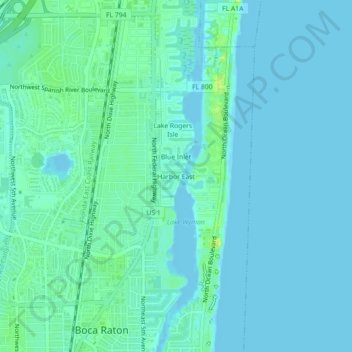
Name: Topografische Karte Harbor East, Höhe, Relief.
Durchschnittliche Höhe: 4 m
Minimale Höhe: -1 m
Maximale Höhe: 19 m
Andere topografische Karten
Klicken Sie auf eine Karte, um ihre Topografie, ihre Höhe und ihr Relief anzuzeigen.
Boca Raton
United States > Florida > Palm Beach County > Boca Raton
Boca Raton, Palm Beach County, Florida, 33432, United States
Durchschnittliche Höhe: 4 m
Royal Oak Hills
United States > Florida > Palm Beach County > Boca Raton
Royal Oak Hills, Boca Raton, Palm Beach County, Florida, 33432, United States
Durchschnittliche Höhe: 7 m
Caribbean Key
United States > Florida > Palm Beach County > Boca Raton > Caribbean Key
Caribbean Key, Boca Raton, Palm Beach County, Florida, 33487, United States
Durchschnittliche Höhe: 5 m
Paradise Palms
United States > Florida > Palm Beach County > Boca Raton
Paradise Palms, Boca Raton, Palm Beach County, Florida, 33486, United States
Durchschnittliche Höhe: 8 m