
Topografische Karte Landersdale
Interaktive Karte
Klicken Sie auf die Karte, um die Höhe anzuzeigen.
Über diese Karte
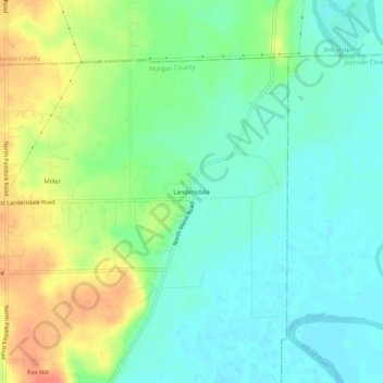
Name: Topografische Karte Landersdale, Höhe, Relief.
Ort: Landersdale, Morgan County, Indiana, 46183, United States (39.59949 -86.28305 39.63949 -86.24305)
Durchschnittliche Höhe: 211 m
Minimale Höhe: 194 m
Maximale Höhe: 240 m
Andere topografische Karten
Klicken Sie auf eine Karte, um ihre Topografie, ihre Höhe und ihr Relief anzuzeigen.
Paragon
United States > Indiana > Morgan County
Paragon, Morgan County, Indiana, United States
Durchschnittliche Höhe: 176 m
Morgantown
United States > Indiana > Morgan County
Morgantown, Morgan County, Indiana, United States
Durchschnittliche Höhe: 209 m
Martinsville
United States > Indiana > Morgan County
Martinsville, Morgan County, Indiana, United States
Durchschnittliche Höhe: 197 m
Brookmoor
United States > Indiana > Morgan County > Mooresville
Brookmoor, Mooresville, Morgan County, Indiana, 46158, United States
Durchschnittliche Höhe: 215 m
Mooresville
United States > Indiana > Morgan County
Mooresville, Morgan County, Indiana, United States
Durchschnittliche Höhe: 223 m
Monrovia
United States > Indiana > Morgan County
Monrovia, Morgan County, Indiana, United States
Durchschnittliche Höhe: 237 m