
Topografische Karte Pinios (Thessalia)
Interaktive Karte
Klicken Sie auf die Karte, um die Höhe anzuzeigen.
Über diese Karte
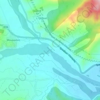
Name: Topografische Karte Pinios (Thessalia), Höhe, Relief.
Durchschnittliche Höhe: 288 m
Minimale Höhe: 242 m
Maximale Höhe: 486 m
Andere topografische Karten
Klicken Sie auf eine Karte, um ihre Topografie, ihre Höhe und ihr Relief anzuzeigen.
Sergoula Beach
Greece > Thessaly and Central Greece > Regional Unit of Phocis > Municipal Unit of Efpalio > Κοινότητα Σεργούλας > Παραλία Σεργούλας
Sergoula Beach, Παραλία Σεργούλας, Κοινότητα Σεργούλας, Municipal Unit of Efpalio, Dorida Municipality, Regional Unit of Phocis, Central Greece, Thessaly and Central Greece, 330 56, Greece
Durchschnittliche Höhe: 69 m
Eratini
Greece > Thessaly and Central Greece > Regional Unit of Phocis > Municipal Unit of Tolofona
Eratini, Municipal Unit of Tolofona, Dorida Municipality, Regional Unit of Phocis, Central Greece, Thessaly and Central Greece, 330 58, Greece
Durchschnittliche Höhe: 46 m