Geolokalisieren
👉 Easily get elevation data in JSON, GeoTIFF and KML formats using Elevation API
Vielen Dank für die Unterstützung dieser Website ❤️
Spenden

Topografische Karte Meyrueis

Klicken Sie auf die Karte, um die Höhe anzuzeigen.

👉 Easily get elevation data in JSON, GeoTIFF and KML formats using Elevation API
Vielen Dank für die Unterstützung dieser Website ❤️
Spenden

Meyrueis

The town of Meyrueis is located between the foothills of Mont Aigoual to the south and the Causse Méjean to the north. The town thus marks the border between the geographic areas of the Grands Causses, Causse Noir and Causse Méjean, and the Cévennes Mountains. Three rivers meet there: the Jonte, the Béthuzon and the Brèze. The communal territory extends across 10,468 hectares, delimited by an approximate rectangle 25 km long and 10 km wide. It has an average altitude of 706 metres; the highest point is 1562 metres.

Wikipedia (CC-BY-SA 3.0)

👉 Easily get elevation data in JSON, GeoTIFF and KML formats using Elevation API
Vielen Dank für die Unterstützung dieser Website ❤️
Spenden

Über diese Karte

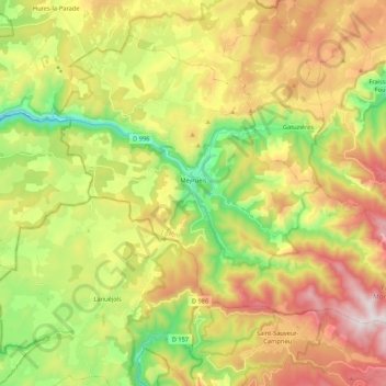
Name: Topografische Karte Meyrueis, Höhe, Relief.

Ort: Meyrueis, Florac, Lozère, Occitania, Metropolitan France, 48150, France (44.10934 3.35671 44.23514 3.57075)

Durchschnittliche Höhe: 993 m

Minimale Höhe: 591 m

Maximale Höhe: 1.483 m

👉 Easily get elevation data in JSON, GeoTIFF and KML formats using Elevation API
Vielen Dank für die Unterstützung dieser Website ❤️
Spenden

Andere topografische Karten

Klicken Sie auf eine Karte, um ihre Topografie, ihre Höhe und ihr Relief anzuzeigen.

Thonas

France > Occitania > Lozère > Saint-Germain-de-Calberte

Durchschnittliche Höhe: 463 m

Salèles

France > Occitania > Lozère > Peyre en Aubrac

Durchschnittliche Höhe: 1.153 m

Cassagnes

France > Occitania > Lozère > Saint-Pierre-des-Tripiers > Cassagnes

Durchschnittliche Höhe: 720 m

Saint-Prejet

France > Occitania > Lozère > Massegros Causses Gorges

Durchschnittliche Höhe: 788 m

Vielen Dank für die Unterstützung dieser Website ❤️
Spenden

Truc de Bringer

France > Occitania > Lozère > Saint-Chély-d'Apcher

Durchschnittliche Höhe: 1.013 m