
Topografische Karte Peermade
Klicken Sie auf die Karte, um die Höhe anzuzeigen.
Peermade
The landscape of Peermade includes spectacular waterfalls, open grass lands and pine forests. Predominantly it is classified as Malanad with an elevation ranging from 3,000 ft (910 m) from the mean sea level.
Über diese Karte
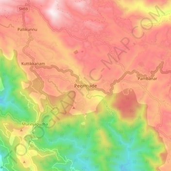
Name: Topografische Karte Peermade, Höhe, Relief.
Ort: Peermade, Peerumade, Idukki, Kerala, 685531, India (9.53201 76.95590 9.61201 77.03590)
Durchschnittliche Höhe: 918 m
Minimale Höhe: 300 m
Maximale Höhe: 1.399 m
Andere topografische Karten
Klicken Sie auf eine Karte, um ihre Topografie, ihre Höhe und ihr Relief anzuzeigen.
Periyar National Park Tiger Reserve
Periyar National Park lies in the middle of a mountainous area of the Cardamom Hills. In the north : The boundary commences from the point nearest to the Medaganam in the interstate boundary up to Vellimalai. and the east Thence the boundary follows the inter-state boundary from Vellimalai to Kallimalai Peak…
Durchschnittliche Höhe: 929 m