
Topografische Karte Switz City
Interaktive Karte
Klicken Sie auf die Karte, um die Höhe anzuzeigen.
Über diese Karte
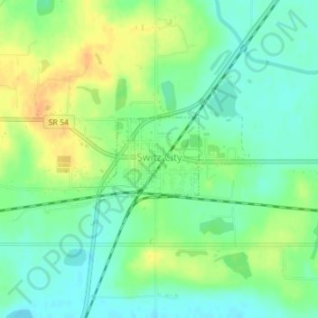
Name: Topografische Karte Switz City, Höhe, Relief.
Ort: Switz City, Greene County, Indiana, 47465, United States (39.03123 -87.05970 39.03840 -87.04869)
Durchschnittliche Höhe: 162 m
Minimale Höhe: 148 m
Maximale Höhe: 180 m
Andere topografische Karten
Klicken Sie auf eine Karte, um ihre Topografie, ihre Höhe und ihr Relief anzuzeigen.
Worthington
United States > Indiana > Greene County
Worthington, Greene County, Indiana, 47471, United States
Durchschnittliche Höhe: 162 m
Linton
United States > Indiana > Greene County
Linton, Greene County, Indiana, 47441, United States
Durchschnittliche Höhe: 161 m
Bloomfield
United States > Indiana > Greene County
Bloomfield, Greene County, Indiana, 47424, United States
Durchschnittliche Höhe: 168 m
Shakamak State Park
United States > Indiana > Greene County
Shakamak State Park, Greene County, Indiana, United States
Durchschnittliche Höhe: 175 m
White Rose
United States > Indiana > Greene County
White Rose, Greene County, Indiana, United States
Durchschnittliche Höhe: 156 m
Owensburg
United States > Indiana > Greene County > Owensburg
Owensburg, Greene County, Indiana, 47453, United States
Durchschnittliche Höhe: 223 m