
Spenden
Topografische Karte Chilterns National Landscape
Klicken Sie auf die Karte, um die Höhe anzuzeigen.
Spenden
Chilterns National Landscape
The highest point is at 267 m (876 ft.) above sea level at Haddington Hill near Wendover in Buckinghamshire; a stone monument marks the summit. The nearby Ivinghoe Beacon is a more prominent hill, although its altitude is only 249 m (817 ft.). It is the starting point of the Icknield Way Path and the Ridgeway long-distance path, which follows the line of the Chiltern Hill for many miles to the west, where they merge with the Wiltshire downs and southern Cotswolds. To the east of Ivinghoe Beacon is Dunstable Downs, a steep section of the Chiltern scarp. Near Wendover is Coombe Hill, 260 m (852 ft.) above sea level. The more gently sloping country – the dip slope – to the southeast of the Chiltern scarp is also generally referred to as part of the Chiltern Hills; it contains much beech woodland and many villages.
Spenden
Über diese Karte
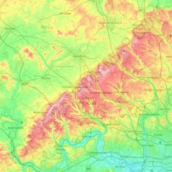
Name: Topografische Karte Chilterns National Landscape, Höhe, Relief.
Durchschnittliche Höhe: 102 m
Minimale Höhe: 14 m
Maximale Höhe: 269 m
Spenden
Andere topografische Karten
Klicken Sie auf eine Karte, um ihre Topografie, ihre Höhe und ihr Relief anzuzeigen.
Spenden
Spenden
Spenden
Spenden
Spenden
Horsleys Green
United Kingdom > England > Buckinghamshire > Studley Green
Durchschnittliche Höhe: 176 m
Spenden
Spenden
Spenden
Spenden
Beacon's Bottom
United Kingdom > England > Buckinghamshire > Studley Green
Durchschnittliche Höhe: 175 m
Spenden
Spenden
Hotley Bottom
United Kingdom > England > Buckinghamshire > Great Missenden > Prestwood
Durchschnittliche Höhe: 182 m
Rammamere Heath
United Kingdom > England > Buckinghamshire > Heath and Reach
Durchschnittliche Höhe: 138 m
Spenden
Spenden
Spenden
Spenden
Doddershall Wood
United Kingdom > England > Buckinghamshire > Grendon Underwood
Durchschnittliche Höhe: 77 m
Ivinghoe Beacon
United Kingdom > England > Buckinghamshire > Ivinghoe Aston
Durchschnittliche Höhe: 149 m
Spenden
Spenden
Egyptian Spring
United Kingdom > England > Buckinghamshire > Fairford Leys
Durchschnittliche Höhe: 86 m
Spenden
Spenden
Spenden
Village Pond
United Kingdom > England > Buckinghamshire > Chalfont St Giles
Durchschnittliche Höhe: 102 m
Spenden
Spenden
Spenden