
Topografische Karte Dion-Valmont
Interaktive Karte
Klicken Sie auf die Karte, um die Höhe anzuzeigen.
Über diese Karte
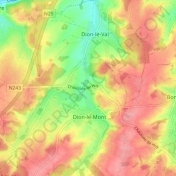
Name: Topografische Karte Dion-Valmont, Höhe, Relief.
Durchschnittliche Höhe: 94 m
Minimale Höhe: 42 m
Maximale Höhe: 130 m
Andere topografische Karten
Klicken Sie auf eine Karte, um ihre Topografie, ihre Höhe und ihr Relief anzuzeigen.
Corroy-le-Grand
Belgique > Brabant wallon > Nivelles > Chaumont-Gistoux
Corroy-le-Grand, Chaumont-Gistoux, Nivelles, Brabant wallon, Wallonie, Belgique
Durchschnittliche Höhe: 124 m
Le Tri
Belgique > Brabant wallon > Nivelles > Chaumont-Gistoux
Le Tri, Longueville, Chaumont-Gistoux, Nivelles, Brabant wallon, Wallonie, Belgique
Durchschnittliche Höhe: 126 m
Panorama
Belgique > Brabant wallon > Nivelles > Chaumont-Gistoux > Bonlez
Panorama, Bonlez, Chaumont-Gistoux, Nivelles, Brabant wallon, Wallonie, 1390, Belgique
Durchschnittliche Höhe: 97 m
Bonlez
Belgique > Brabant wallon > Nivelles > Chaumont-Gistoux
Bonlez, Chaumont-Gistoux, Nivelles, Brabant wallon, Wallonie, Belgique
Durchschnittliche Höhe: 97 m
Dion-le-Val
Belgique > Brabant wallon > Nivelles > Chaumont-Gistoux
Dion-le-Val, Chaumont-Gistoux, Nivelles, Brabant wallon, Wallonie, 1325, Belgique
Durchschnittliche Höhe: 82 m
Dion-le-Mont
Belgique > Brabant wallon > Nivelles > Chaumont-Gistoux
Dion-le-Mont, Chaumont-Gistoux, Nivelles, Brabant wallon, Wallonie, 1325, Belgique
Durchschnittliche Höhe: 100 m
Vieusart
Belgique > Brabant wallon > Nivelles > Chaumont-Gistoux > Vieusart
Vieusart, Chaumont-Gistoux, Nivelles, Brabant wallon, Wallonie, 1348, Belgique
Durchschnittliche Höhe: 124 m
El Pirère
Belgique > Brabant wallon > Nivelles > Chaumont-Gistoux > El Pirère
El Pirère, Dion-Valmont, Chaumont-Gistoux, Nivelles, Brabant wallon, Wallonie, 1348, Belgique
Durchschnittliche Höhe: 111 m