
Topografische Karte Condamine River
Klicken Sie auf die Karte, um die Höhe anzuzeigen.
Über diese Karte
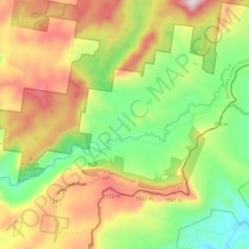
Name: Topografische Karte Condamine River, Höhe, Relief.
Ort: Condamine River, Warwick, Queensland, 4370, Australia (-28.29617 152.37167 -28.25843 152.45957)
Durchschnittliche Höhe: 844 m
Minimale Höhe: 496 m
Maximale Höhe: 1.274 m
Andere topografische Karten
Klicken Sie auf eine Karte, um ihre Topografie, ihre Höhe und ihr Relief anzuzeigen.
Warwick
Australia > Queensland > Warwick
Warwick has a humid subtropical climate (Köppen Cfa) with hot summers and cool to cold winters. It is slightly cooler and less humid than the proximate southeast Queensland coast due to its inland, elevation location. Frost is present in winter. The climate bears similarities with Richmond, an inland suburb…
Durchschnittliche Höhe: 517 m