
Spenden
Topografische Karte Innertkirchen
Klicken Sie auf die Karte, um die Höhe anzuzeigen.
Spenden
Innertkirchen
The large alpine municipality is located at the confluence of the Urbach and Gadmer streams into the Aare river. It includes the Urbach valley, the Gadmen valley, the Gen valley, the Wetterhorn mountain and the Gauli Glacier. Innertkirchen was created out of the Bäuerten (farming communities) of Grund, Bottigen, Wyler-Schattseite, Wyler-Sonnseite and the agricultural cooperative of Äppigen in 1834. The merger with Gadmen almost doubled the size the municipality. Gadmen lies in the Bernese Oberland with the Susten Pass on the eastern border of the former municipality. The municipal borders stretch from the valley floor, with an elevation of 850–1,250 m (2,790–4,100 ft), up to the nearby mountain peaks at about 3,500 m (11,500 ft). It is located on the border of the Canton of Bern with the Cantons of Obwalden, Nidwalden, Uri and Valais.
Spenden
Über diese Karte
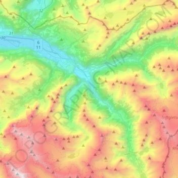
Name: Topografische Karte Innertkirchen, Höhe, Relief.
Durchschnittliche Höhe: 1.945 m
Minimale Höhe: 570 m
Maximale Höhe: 4.023 m
Spenden
Andere topografische Karten
Klicken Sie auf eine Karte, um ihre Topografie, ihre Höhe und ihr Relief anzuzeigen.
Underburg
Switzerland > Bern > Interlaken-Oberhasli administrative district > Innertkirchen > Wychel
Durchschnittliche Höhe: 912 m
Triftsee
Switzerland > Bern > Interlaken-Oberhasli administrative district > Innertkirchen
Durchschnittliche Höhe: 2.025 m
Wychel
Switzerland > Bern > Interlaken-Oberhasli administrative district > Innertkirchen
Durchschnittliche Höhe: 992 m
Underburg
Switzerland > Bern > Interlaken-Oberhasli administrative district > Innertkirchen > Wychel
Durchschnittliche Höhe: 912 m
Spenden
Spis
Switzerland > Bern > Interlaken-Oberhasli administrative district > Innertkirchen > Äppigen
Durchschnittliche Höhe: 871 m