
Topografische Karte Chad Lake
Interaktive Karte
Klicken Sie auf die Karte, um die Höhe anzuzeigen.
Über diese Karte
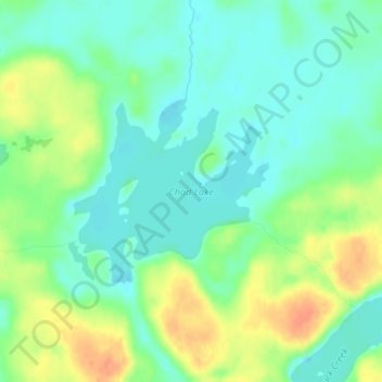
Name: Topografische Karte Chad Lake, Höhe, Relief.
Ort: Chad Lake, Saint Louis County, Minnesota, USA (47.96637 -92.23489 47.97939 -92.21421)
Durchschnittliche Höhe: 441 m
Minimale Höhe: 426 m
Maximale Höhe: 466 m
Andere topografische Karten
Klicken Sie auf eine Karte, um ihre Topografie, ihre Höhe und ihr Relief anzuzeigen.
Alexandria
USA > Minnesota > Alexandria
Alexandria, Douglas County, Minnesota, 56308, USA
Durchschnittliche Höhe: 426 m
Hula Lake
USA > Minnesota > Silver Rapids
Hula Lake, Fernberg Trl; Fernberg Rd, Silver Rapids, Lake County, Minnesota, USA
Durchschnittliche Höhe: 411 m
Kettle River
Kettle River, Carlton County, Minnesota, 55757, USA
Durchschnittliche Höhe: 367 m
Lake of the Woods County
Lake of the Woods County, Minnesota, USA
Durchschnittliche Höhe: 343 m
Wenonah
USA > Minnesota > Minneapolis
Wenonah, Minneapolis, Hennepin County, Minnesota, USA
Durchschnittliche Höhe: 255 m
Keller Lake
Keller Lake, North Maplewood Drive, Maplewood, Ramsey County, Minnesota, 55109, USA
Durchschnittliche Höhe: 272 m