
Topografische Karte Bloomfield
Interaktive Karte
Klicken Sie auf die Karte, um die Höhe anzuzeigen.
Über diese Karte
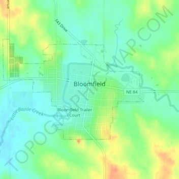
Name: Topografische Karte Bloomfield, Höhe, Relief.
Ort: Bloomfield, Knox County, Nebraska, 68718, United States (42.59044 -97.66342 42.60563 -97.63442)
Durchschnittliche Höhe: 527 m
Minimale Höhe: 510 m
Maximale Höhe: 556 m
Andere topografische Karten
Klicken Sie auf eine Karte, um ihre Topografie, ihre Höhe und ihr Relief anzuzeigen.
Center
United States > Nebraska > Knox County
Center, Knox County, Nebraska, United States
Durchschnittliche Höhe: 451 m
Creighton
United States > Nebraska > Knox County
Creighton, Knox County, Nebraska, 68729, United States
Durchschnittliche Höhe: 499 m
Bloomfield Trailer Court
United States > Nebraska > Knox County > Bloomfield
Bloomfield Trailer Court, Bloomfield, Knox County, Nebraska, 68718, United States
Durchschnittliche Höhe: 530 m
Crofton
United States > Nebraska > Knox County > Crofton
Crofton, Knox County, Nebraska, United States
Durchschnittliche Höhe: 437 m