
Topografische Karte Santa Clara
Interaktive Karte
Klicken Sie auf die Karte, um die Höhe anzuzeigen.
Über diese Karte
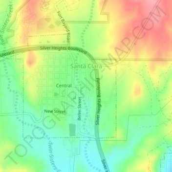
Name: Topografische Karte Santa Clara, Höhe, Relief.
Durchschnittliche Höhe: 1.833 m
Minimale Höhe: 1.785 m
Maximale Höhe: 1.892 m
Andere topografische Karten
Klicken Sie auf eine Karte, um ihre Topografie, ihre Höhe und ihr Relief anzuzeigen.
Silver City
United States > New Mexico > Grant County
Silver City, Grant County, New Mexico, 88062, United States
Durchschnittliche Höhe: 1.850 m
Hurley
United States > New Mexico > Grant County
Hurley, Grant County, New Mexico, United States
Durchschnittliche Höhe: 1.734 m
Bayard
United States > New Mexico > Grant County
Bayard, Grant County, New Mexico, 88023, United States
Durchschnittliche Höhe: 1.816 m
Arenas Valley
United States > New Mexico > Grant County > Silver City
Arenas Valley, Silver City, Grant County, New Mexico, 88022, United States
Durchschnittliche Höhe: 1.873 m
Mallet Pond
United States > New Mexico > Grant County
Mallet Pond, Grant County, New Mexico, United States
Durchschnittliche Höhe: 1.802 m
Dwyer
United States > New Mexico > Grant County
Dwyer, Grant County, New Mexico, 88034, United States
Durchschnittliche Höhe: 1.616 m
Pinos Altos
United States > New Mexico > Grant County
Pinos Altos, Grant County, New Mexico, 88053, United States
Durchschnittliche Höhe: 2.142 m
Aldo Leopold Wilderness
United States > New Mexico > Grant County
Aldo Leopold Wilderness, Grant County, New Mexico, United States
Durchschnittliche Höhe: 2.249 m