
Topografische Karte Derry/Londonderry
Interaktive Karte
Klicken Sie auf die Karte, um die Höhe anzuzeigen.
Über diese Karte
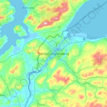
Name: Topografische Karte Derry/Londonderry, Höhe, Relief.
Durchschnittliche Höhe: 88 m
Minimale Höhe: -5 m
Maximale Höhe: 478 m
Derry is characterised by its distinctively hilly topography. The River Foyle forms a deep valley as it flows through the city, making Derry a place of very steep streets and sudden, startling views. The original walled city of Londonderry lies on a hill on the west bank of the River Foyle. In the past, the river branched and enclosed this wooded hill as an island; over the centuries, however, the western branch of the river dried up and became a low-lying and boggy district that is now called the Bogside.
Andere topografische Karten
Klicken Sie auf eine Karte, um ihre Topografie, ihre Höhe und ihr Relief anzuzeigen.
Eagle Hill
United Kingdom > Northern Ireland > County Londonderry
Eagle Hill, County Londonderry, Northern Ireland, BT49 0LG, United Kingdom
Durchschnittliche Höhe: 113 m
Mountsandel
United Kingdom > Northern Ireland > County Londonderry > Coleraine
Mountsandel, Fortsandel Avenue, Coleraine, County Londonderry, Northern Ireland, BT52 1JL, United Kingdom
Durchschnittliche Höhe: 25 m
Dungannon Fort
United Kingdom > Northern Ireland > County Londonderry > Castlerock > Downhill
Dungannon Fort, Mussenden Road, Downhill, Castlerock, County Londonderry, Northern Ireland, BT51 4RH, United Kingdom
Durchschnittliche Höhe: 60 m
Maghera
United Kingdom > Northern Ireland > County Londonderry > Maghera
Maghera, County Londonderry, Northern Ireland, BT46 5AE, United Kingdom
Durchschnittliche Höhe: 72 m
Tobermore
United Kingdom > Northern Ireland > County Londonderry > Tobermore
Tobermore, County Londonderry, Northern Ireland, BT45 5QB, United Kingdom
Durchschnittliche Höhe: 50 m
Moneymore
United Kingdom > Northern Ireland > County Londonderry
Moneymore, County Londonderry, Ulster, Northern Ireland, BT45 7NG, United Kingdom
Durchschnittliche Höhe: 71 m
Binevenagh
United Kingdom > Northern Ireland > County Londonderry
Binevenagh, County Londonderry, Northern Ireland, BT49 0JB, United Kingdom
Durchschnittliche Höhe: 246 m