
Topografische Karte Malaspina Glacier
Interaktive Karte
Klicken Sie auf die Karte, um die Höhe anzuzeigen.
Malaspina Glacier
The Malaspina is up to 600 meters (2,000 ft) thick in places, with the elevation of its bottom being estimated to be as much as 300 m (980 ft) below sea level.[4] There are two lakes on its margins: Oily Lake to the northwest, at the foot of the Samovar Hills between the Agassiz and Seward glaciers, and Malaspina Lake to the southeast, close to Yakutat Bay.
Über diese Karte
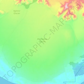
Name: Topografische Karte Malaspina Glacier, Höhe, Relief.
Ort: Malaspina Glacier, Yakutat, Alaska, United States (59.74222 -140.95854 60.13048 -140.14049)
Durchschnittliche Höhe: 393 m
Minimale Höhe: -3 m
Maximale Höhe: 2.086 m
Andere topografische Karten
Klicken Sie auf eine Karte, um ihre Topografie, ihre Höhe und ihr Relief anzuzeigen.