
Spenden
Topografische Karte Koronadal
Klicken Sie auf die Karte, um die Höhe anzuzeigen.
Spenden
Koronadal
The city's landscape features a combination of flatlands and gently sloping terrain, with approximately 50.18% of its total land area classified as predominantly flat. It is flanked by the Roxas and Quezon mountain ranges, whose elevations reach between 700 to 800 meters above sea level and gradually slope downward toward the city center.
Spenden
Über diese Karte
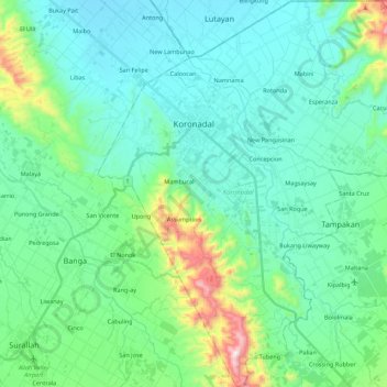
Name: Topografische Karte Koronadal, Höhe, Relief.
Ort: Koronadal, South Cotabato, Soccsksargen, 9506, Philippines (6.35177 124.78885 6.56980 125.00042)
Durchschnittliche Höhe: 164 m
Minimale Höhe: 13 m
Maximale Höhe: 808 m
Spenden
Andere topografische Karten
Klicken Sie auf eine Karte, um ihre Topografie, ihre Höhe und ihr Relief anzuzeigen.
Lake Sebu
The placid lake of Lake Sebu can be found in Allah Valley near the municipality of Surallah, South Cotabato. Surrounded by rolling hills and mountains covered with thick rain forest, the lake has an area of 361.124 hectares (892.36 acres), with an elevation of approximately 1,000 metres (3,300 ft).
Durchschnittliche Höhe: 750 m
Mount Matutum
Philippines > South Cotabato > Tupi
Mount Matutum is an active stratovolcano, is the highest point in the province of South Cotabato in the Philippines, with an elevation of 7,500 feet (2,286 metres) above sea level, approximately 5.7 kilometres (3.5 mi) from Acmonan, Tupi, South Cotabato. Matutum and its foothills are predominantly inhabited by…
Durchschnittliche Höhe: 1.659 m
Spenden
Spenden
Spenden
Spenden
Spenden
Spenden
Spenden
Spenden
Spenden
Spenden
Mount Matutum
Philippines > South Cotabato > Polomolok
Mount Matutum is an active stratovolcano, is the highest point in the province of South Cotabato in the Philippines, with an elevation of 7,500 feet (2,286 metres) above sea level, approximately 5.7 kilometres (3.5 mi) from Acmonan, Tupi, South Cotabato. Matutum and its foothills are predominantly inhabited by…
Durchschnittliche Höhe: 1.659 m
Spenden
Spenden
Spenden
Spenden
Lake Sebu
The placid lake of Lake Sebu can be found in Allah Valley near the municipality of Surallah, South Cotabato. Surrounded by rolling hills and mountains covered with thick rain forest, the lake has an area of 354 hectares (870 acres), with an elevation of approximately 1,000 metres (3,300 ft).
Durchschnittliche Höhe: 750 m