
Topografische Karte McClelland
Interaktive Karte
Klicken Sie auf die Karte, um die Höhe anzuzeigen.
Über diese Karte
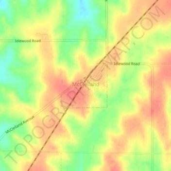
Name: Topografische Karte McClelland, Höhe, Relief.
Ort: McClelland, Pottawattamie County, Iowa, United States (41.32567 -95.68925 41.33270 -95.67954)
Durchschnittliche Höhe: 369 m
Minimale Höhe: 335 m
Maximale Höhe: 390 m
Andere topografische Karten
Klicken Sie auf eine Karte, um ihre Topografie, ihre Höhe und ihr Relief anzuzeigen.
Avoca
United States > Iowa > Pottawattamie County
Avoca, Pottawattamie County, Iowa, 51521, United States
Durchschnittliche Höhe: 353 m
Bentley
United States > Iowa > Pottawattamie County
Bentley, Pottawattamie County, Iowa, 51548, United States
Durchschnittliche Höhe: 368 m
Underwood
United States > Iowa > Pottawattamie County
Underwood, Pottawattamie County, Iowa, United States
Durchschnittliche Höhe: 339 m