
Topografische Karte Mount Magazine State Park
Interaktive Karte
Klicken Sie auf die Karte, um die Höhe anzuzeigen.
Über diese Karte
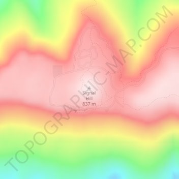
Name: Topografische Karte Mount Magazine State Park, Höhe, Relief.
Durchschnittliche Höhe: 667 m
Minimale Höhe: 373 m
Maximale Höhe: 839 m
There also exist many opportunities for ATV riding, backpacking, hang gliding, mountain biking, rappelling, and rock climbing within the park. The park hosts the annual Mount Magazine International Butterfly Festival, and is a haven for many rare species of butterflies in Arkansas due to the special blend of altitude and temperature available. The state butterfly, the Diana fritillary, is found almost exclusively in the Arkansas River Valley and the Petit Jean River Valley.
Andere topografische Karten
Klicken Sie auf eine Karte, um ihre Topografie, ihre Höhe und ihr Relief anzuzeigen.
Booneville
United States > Arkansas > Logan County
Booneville, Logan County, Arkansas, 72927, United States
Durchschnittliche Höhe: 153 m
Saint Scholastica
United States > Arkansas > Logan County
Saint Scholastica, Logan County, Arkansas, 72851, United States
Durchschnittliche Höhe: 142 m
Driggs
United States > Arkansas > Logan County
Driggs, Logan County, Arkansas, United States
Durchschnittliche Höhe: 227 m
Paris
United States > Arkansas > Logan County
Paris, Logan County, Arkansas, 72855, United States
Durchschnittliche Höhe: 165 m