
Spenden
Topografische Karte Gadahinglaj
Klicken Sie auf die Karte, um die Höhe anzuzeigen.
Spenden
Gadahinglaj
Gadhinglaj is situated on the banks of the Hiranyakeshi river, which originates in the Amboli Ghats mountains. It is located at the border between Maharashtra and Karnataka. Maharashtra State Highway 134 passes through the city. Gadinglaj is the headquarters of South Kolhapur and a sub-district of the Kolhapur District. It is the largest city in South Kolhapur and has enough area and population to be deemed a district. The city is at an average elevation of 623 metres (2,044 ft).
Spenden
Über diese Karte
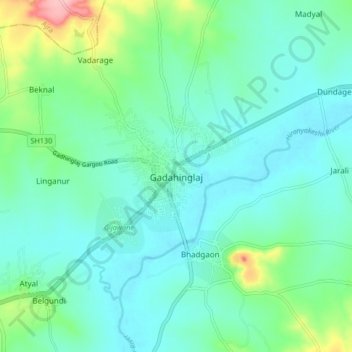
Name: Topografische Karte Gadahinglaj, Höhe, Relief.
Ort: Gadahinglaj, Gadhinglaj, Kolhapur, Maharashtra, 416502, India (16.18369 74.31159 16.26369 74.39159)
Durchschnittliche Höhe: 655 m
Minimale Höhe: 624 m
Maximale Höhe: 773 m
Spenden
Andere topografische Karten
Klicken Sie auf eine Karte, um ihre Topografie, ihre Höhe und ihr Relief anzuzeigen.