
Topografische Karte Town of Brookfield
Interaktive Karte
Klicken Sie auf die Karte, um die Höhe anzuzeigen.
Über diese Karte
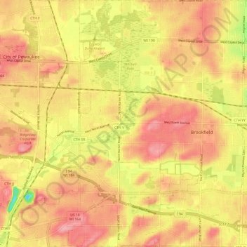
Name: Topografische Karte Town of Brookfield, Höhe, Relief.
Durchschnittliche Höhe: 263 m
Minimale Höhe: 194 m
Maximale Höhe: 301 m
Andere topografische Karten
Klicken Sie auf eine Karte, um ihre Topografie, ihre Höhe und ihr Relief anzuzeigen.
Muskego
United States > Wisconsin > Waukesha County
Muskego, Waukesha County, Wisconsin, 53150, United States
Durchschnittliche Höhe: 248 m
Kettle Moraine State Forest - Lapham Peak Unit
United States > Wisconsin > Waukesha County > Delafield
Kettle Moraine State Forest - Lapham Peak Unit, W329 N846, South Cushing Park Road, Delafield, Town of Delafield, Waukesha County, Wisconsin, 53018, United States
Durchschnittliche Höhe: 306 m
Hartland
United States > Wisconsin > Waukesha County
Hartland, Waukesha County, Wisconsin, United States
Durchschnittliche Höhe: 289 m
Oconomowoc
United States > Wisconsin > Waukesha County
Oconomowoc, Waukesha County, Wisconsin, United States
Durchschnittliche Höhe: 267 m
Menomonee Falls
United States > Wisconsin > Waukesha County > Menomonee Falls
Menomonee Falls, Waukesha County, Wisconsin, 53051, United States
Durchschnittliche Höhe: 260 m
Town of Delafield
United States > Wisconsin > Waukesha County > Town of Delafield
Town of Delafield, Waukesha County, Wisconsin, United States
Durchschnittliche Höhe: 291 m
Delafield
United States > Wisconsin > Waukesha County > Delafield
Delafield, Waukesha County, Wisconsin, 53018, United States
Durchschnittliche Höhe: 283 m
Mukwonago Park
United States > Wisconsin > Waukesha County
Mukwonago Park, Town of Mukwonago, Waukesha County, Wisconsin, 53149, United States
Durchschnittliche Höhe: 267 m
Wales
United States > Wisconsin > Waukesha County
Wales, Waukesha County, Wisconsin, 53183, United States
Durchschnittliche Höhe: 302 m
Waukesha
United States > Wisconsin > Waukesha County
Waukesha, Waukesha County, Wisconsin, United States
Durchschnittliche Höhe: 268 m
Brookfield
United States > Wisconsin > Waukesha County > Brookfield
Brookfield, Waukesha County, Wisconsin, United States
Durchschnittliche Höhe: 251 m
Sussex
United States > Wisconsin > Waukesha County
Sussex, Waukesha County, Wisconsin, 53089, United States
Durchschnittliche Höhe: 286 m
Village of Pewaukee
United States > Wisconsin > Waukesha County > Village of Pewaukee
Village of Pewaukee, Waukesha County, Wisconsin, 53072, United States
Durchschnittliche Höhe: 269 m