Geolokalisieren
👉 Easily get elevation data in JSON, GeoTIFF and KML formats using Elevation API
Vielen Dank für die Unterstützung dieser Website ❤️
Spenden

Topografische Karte Valencia

Klicken Sie auf die Karte, um die Höhe anzuzeigen.

👉 Easily get elevation data in JSON, GeoTIFF and KML formats using Elevation API
Vielen Dank für die Unterstützung dieser Website ❤️
Spenden

Valencia

The city's topography is characterized as flat to undulating hills with extensive plateaus and mountainous areas and cliffs on both eastern and western portions bounding the municipality of San Fernando on the east and the municipality of Talakag on the west. Its highest point is Mount Kalatungan in the Kalatungan Mountain Range rising above 1,000 meters and above 50 percent slopes. These cover 25.72 percent of the total city area and major portions of Barangay of Lourdes, Guinoyuran and Lilingayon.

Wikipedia (CC-BY-SA 3.0)

👉 Easily get elevation data in JSON, GeoTIFF and KML formats using Elevation API
Vielen Dank für die Unterstützung dieser Website ❤️
Spenden

Über diese Karte

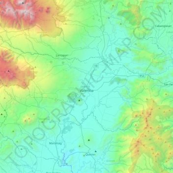
Name: Topografische Karte Valencia, Höhe, Relief.

Ort: Valencia, Bukidnon, Northern Mindanao, 8709, Philippines (7.79163 124.80269 8.03586 125.27332)

Durchschnittliche Höhe: 736 m

Minimale Höhe: 182 m

Maximale Höhe: 2.878 m

👉 Easily get elevation data in JSON, GeoTIFF and KML formats using Elevation API
Vielen Dank für die Unterstützung dieser Website ❤️
Spenden

Andere topografische Karten

Klicken Sie auf eine Karte, um ihre Topografie, ihre Höhe und ihr Relief anzuzeigen.

Malaybalay

Philippines > Bukidnon

The average elevation of the city is 622 metres (2,041 ft) above sea level. About 60% of the city's area has above 30% slope, characterized by steep hills, mountains, and cliff-like stream side. About 25% are level, gently sloping, and undulating. The rest are rolling and hilly.

Durchschnittliche Höhe: 822 m

Mount Capistrano

Philippines > Bukidnon > Malaybalay

Durchschnittliche Höhe: 404 m

San Francisco

Philippines > Bukidnon > Don Carlos

Durchschnittliche Höhe: 304 m

Pualas

Philippines > Bukidnon > Baungon

Durchschnittliche Höhe: 233 m

Vielen Dank für die Unterstützung dieser Website ❤️
Spenden

Tawas

Philippines > Bukidnon > Kitaotao

Durchschnittliche Höhe: 966 m

Manupali River

Philippines > Bukidnon

Durchschnittliche Höhe: 1.036 m

Bagongsilang

Philippines > Bukidnon > Maramag

Durchschnittliche Höhe: 969 m

Lake Apo

Philippines > Bukidnon > Valencia

Lake Apo is a crater lake in Barangay Guinoyoran in the city of Valencia in Bukidnon province in the Philippines. It is located in a hilly area about 640 metres (2,100 ft) in elevation, about 11 kilometres (6.8 mi) WSW of the city poblacion (town center). Lake Apo was awarded the cleanest inland body of water…

Durchschnittliche Höhe: 643 m

Vielen Dank für die Unterstützung dieser Website ❤️
Spenden

Habyugan

Philippines > Bukidnon > Impasugong

Durchschnittliche Höhe: 566 m

Lapok

Philippines > Bukidnon > Talakag

Durchschnittliche Höhe: 1.445 m

Mambatangan

Philippines > Bukidnon > Manolo Fortich

Durchschnittliche Höhe: 273 m

Kisolon

Philippines > Bukidnon > Sumilao

Durchschnittliche Höhe: 507 m

Vielen Dank für die Unterstützung dieser Website ❤️
Spenden

Tankulan

Philippines > Bukidnon > Talakag

Durchschnittliche Höhe: 1.387 m

Bagontaas

Philippines > Bukidnon > Valencia

Durchschnittliche Höhe: 327 m

Bakayan

Philippines > Bukidnon > Kitaotao

Durchschnittliche Höhe: 981 m

Valencia

Philippines > Bukidnon > Valencia

The city's topography is characterized as flat to undulating hills with extensive plateaus and mountainous areas and cliffs on both eastern and western portions bounding the municipality of San Fernando on the east and the municipality of Talakag on the west. Its highest point is Mount Kalatungan in the…

Durchschnittliche Höhe: 566 m

Vielen Dank für die Unterstützung dieser Website ❤️
Spenden

Can-ayan

Philippines > Bukidnon > Malaybalay

Durchschnittliche Höhe: 727 m

Old Kibangay

Philippines > Bukidnon > Lantapan > Kibangay

Durchschnittliche Höhe: 1.280 m

Lantapan

Philippines > Bukidnon > Lantapan

Durchschnittliche Höhe: 672 m

Tagoloan River

Philippines > Bukidnon > Malaybalay > Can-ayan

Durchschnittliche Höhe: 706 m

Vielen Dank für die Unterstützung dieser Website ❤️
Spenden

Mount Kulago

Philippines > Bukidnon > Impasugong

Durchschnittliche Höhe: 652 m

Musuan

Philippines > Bukidnon > Maramag

Durchschnittliche Höhe: 338 m

Butong

Philippines > Bukidnon > Butong

Durchschnittliche Höhe: 383 m

Busco

Philippines > Bukidnon

Durchschnittliche Höhe: 307 m

Vielen Dank für die Unterstützung dieser Website ❤️
Spenden

Maramag

Philippines > Bukidnon > Maramag

Durchschnittliche Höhe: 297 m

Gango

Philippines > Bukidnon > Gango

Durchschnittliche Höhe: 253 m

Manolo Fortich

Philippines > Bukidnon > Manolo Fortich

Durchschnittliche Höhe: 507 m

Alae

Philippines > Bukidnon > Alae

Durchschnittliche Höhe: 413 m

Vielen Dank für die Unterstützung dieser Website ❤️
Spenden

Portulin

Philippines > Bukidnon > Portulin

Durchschnittliche Höhe: 1.273 m

Panadtalan

Philippines > Bukidnon > Panadtalan

Durchschnittliche Höhe: 329 m

Santo Domingo

Philippines > Bukidnon > Quezon > Santo Domingo

Durchschnittliche Höhe: 486 m

Paitan

Philippines > Bukidnon > Paitan

Durchschnittliche Höhe: 323 m

Vielen Dank für die Unterstützung dieser Website ❤️
Spenden

Bulalang

Philippines > Bukidnon > Bulalang

Durchschnittliche Höhe: 641 m

Batangan

Philippines > Bukidnon > Batangan

Durchschnittliche Höhe: 302 m

Indalasa

Philippines > Bukidnon

Durchschnittliche Höhe: 550 m