
Topografische Karte Stateline
Interaktive Karte
Klicken Sie auf die Karte, um die Höhe anzuzeigen.
Über diese Karte
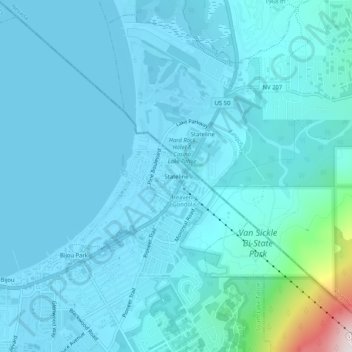
Name: Topografische Karte Stateline, Höhe, Relief.
Durchschnittliche Höhe: 1.978 m
Minimale Höhe: 1.897 m
Maximale Höhe: 2.793 m
Andere topografische Karten
Klicken Sie auf eine Karte, um ihre Topografie, ihre Höhe und ihr Relief anzuzeigen.
Tahoe Valley
United States > California > El Dorado County > South Lake Tahoe
Tahoe Valley, South Lake Tahoe, El Dorado County, California, 96158, United States
Durchschnittliche Höhe: 1.935 m
Tahoe Keys
United States > California > El Dorado County > South Lake Tahoe
Tahoe Keys, South Lake Tahoe, El Dorado County, California, 96152, United States
Durchschnittliche Höhe: 1.994 m
Tallac Village
United States > California > El Dorado County > South Lake Tahoe
Tallac Village, South Lake Tahoe, El Dorado County, California, 96158, United States
Durchschnittliche Höhe: 1.945 m
South Lake Tahoe-El Dorado Recreation Area
United States > California > El Dorado County > South Lake Tahoe > Bijou
South Lake Tahoe-El Dorado Recreation Area, Bijou, South Lake Tahoe, El Dorado County, California, United States
Durchschnittliche Höhe: 1.905 m