
Vielen Dank für die Unterstützung dieser Website ❤️
Spenden
Spenden
Topografische Karte Bari Brahmana
Klicken Sie auf die Karte, um die Höhe anzuzeigen.
Vielen Dank für die Unterstützung dieser Website ❤️
Spenden
Spenden
Bari Brahmana
Bari Brahmana is located at 32°38′N 74°56′E / 32.64°N 74.93°E / 32.64; 74.93. It has an average elevation of 340 metres (1115 feet). The city is just south of Jammu Tawi city and is situated on the banks of Devika river at a flat alluvial plains on the foot hills of the Shiwaliks which surround it on the East and North-east.
Vielen Dank für die Unterstützung dieser Website ❤️
Spenden
Spenden
Über diese Karte
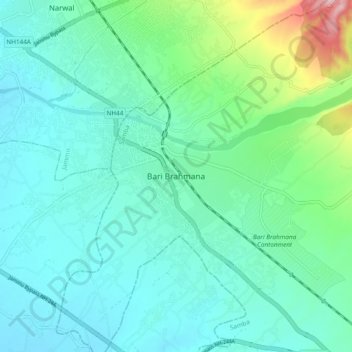
Name: Topografische Karte Bari Brahmana, Höhe, Relief.
Ort: Bari Brahmana, Samba, Jammu and Kashmir, 181133, India (32.59831 74.87524 32.67831 74.95524)
Durchschnittliche Höhe: 339 m
Minimale Höhe: 288 m
Maximale Höhe: 554 m
Vielen Dank für die Unterstützung dieser Website ❤️
Spenden
Spenden