Topografische Karte Ost-Neubritannien
Interaktive Karte
Klicken Sie auf die Karte, um die Höhe anzuzeigen.
Über diese Karte
![Topografische Karte Ost-Neubritannien, Höhe, Relief](/pub/maps/relation/xtzs/7w4zzs/thumbnail.jpg)
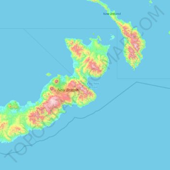
Name: Topografische Karte Ost-Neubritannien, Höhe, Relief.
Ort: Ost-Neubritannien, Islands Region, Papua-Neuguinea (-6.25622 150.60000 -4.00000 154.00000)
Durchschnittliche Höhe: 93 m
Minimale Höhe: 0 m
Maximale Höhe: 2.237 m
Die Provinz East New Britain (ENB) umfasst 15.320 km² und zählte im Jahre 2011 rund 328.369 Einwohner, überwiegend Angehörige des Tolai-Volkes. Größter Ort und Provinzhauptstadt war die Hafenstadt Rabaul – bis 1994 der Ausbruch des Vulkans Tavurvur die Stadt unter seiner Asche begrub (5 Tote). Viele Einwohner zogen während und nach dem Vulkanausbruch ins 30 km entfernte Kokopo (ehemals Herbertshöhe). In der Folge wurde Kokopo Provinzhauptstadt, da der Ort auf Grund seiner geschützten Lage mehr Sicherheit bot und über eine bereits ausgebaute Infrastruktur verfügte. Rabaul hat mittlerweile wieder 4.000 Einwohner, Kokopo etwa 22.000.
Andere topografische Karten
Klicken Sie auf eine Karte, um ihre Topografie, ihre Höhe und ihr Relief anzuzeigen.
![Topografische Karte Südliches Hochland, Höhe, Relief](/pub/maps/relation/r2cz/qhttf/icon.jpg)
Südliches Hochland
Südliches Hochland, Hochlandregion, Papua-Neuguinea
Durchschnittliche Höhe: 1.245 m
![Topografische Karte Östliches Hochland, Höhe, Relief](/pub/maps/relation/d6kl/9rz1h/icon.jpg)
Östliches Hochland
Östliches Hochland, Hochlandregion, Papua-Neuguinea
Durchschnittliche Höhe: 1.498 m
![Topografische Karte Westliches Hochland, Höhe, Relief](/pub/maps/relation/lff3/f5g51/icon.jpg)
Westliches Hochland
Westliches Hochland, Hochlandregion, Papua-Neuguinea
Durchschnittliche Höhe: 1.846 m
![Topografische Karte West-Neubritannien, Höhe, Relief](/pub/maps/relation/5mt6/wjs1t6/icon.jpg)
West-Neubritannien
West-Neubritannien, Islands Region, Papua-Neuguinea
Durchschnittliche Höhe: 57 m
![Topografische Karte Nationaler Hauptstadtdistrikt, Höhe, Relief](/pub/maps/relation/5k3l/1w2nx/icon.jpg)
Nationaler Hauptstadtdistrikt
Nationaler Hauptstadtdistrikt, Southern Region, Papua-Neuguinea
Durchschnittliche Höhe: 50 m
![Topografische Karte Tanga Islands, Höhe, Relief](/pub/maps/relation/g5k/3jkvcz/icon.jpg)
Tanga Islands
Tanga Islands, Namatanai District, Neuirland, Islands Region, Papua-Neuguinea
Durchschnittliche Höhe: 6 m
![Topografische Karte Fergusson-Insel, Höhe, Relief](/pub/maps/node/693l/9wz253zs/icon.jpg)
Fergusson-Insel
Fergusson-Insel, Esa’ala District, Milne Bay, Papua Region, Papua-Neuguinea
Durchschnittliche Höhe: 98 m
![Topografische Karte Kadovar, Höhe, Relief](/pub/maps/way/m8mt/4mgm61h/icon.jpg)
Kadovar
Kadovar, Wewak District, East Sepik, Momase Region, Papua-Neuguinea
Durchschnittliche Höhe: 27 m
![Topografische Karte D’Entrecasteaux Islands, Höhe, Relief](/pub/maps/node/d24s/1lb8w57/icon.jpg)
D’Entrecasteaux Islands
D’Entrecasteaux Islands, Esa’ala District, Milne Bay, Papua Region, Papua-Neuguinea
Durchschnittliche Höhe: 102 m
![Topografische Karte Ritter-Insel, Höhe, Relief](/pub/maps/way/l614/bqcjw1h/icon.jpg)
Ritter-Insel
Ritter-Insel, Finschhafen District, Morobe, Momase Region, Papua-Neuguinea
Durchschnittliche Höhe: 1 m
![Topografische Karte Ulawun, Höhe, Relief](/pub/maps/node/slgp/l3h38rnh/icon.jpg)
Ulawun
Papua-Neuguinea > Ost-Neubritannien
Ulawun, Pomio District, Ost-Neubritannien, Islands Region, Papua-Neuguinea
Durchschnittliche Höhe: 1.708 m
![Topografische Karte Mount Balbi, Höhe, Relief](/pub/maps/node/1dm2/x58gn8t6/icon.jpg)
Mount Balbi
Papua-Neuguinea > Bougainville
Mount Balbi, Buka District, Bougainville, Islands Region, Papua-Neuguinea
Durchschnittliche Höhe: 2.393 m
![Topografische Karte Sepik River, Höhe, Relief](/pub/maps/relation/xp57/91lnh/icon.jpg)
Sepik River
Sepik River, Ambunti District, East Sepik, Momase Region, Papua-Neuguinea
Durchschnittliche Höhe: 648 m
![Topografische Karte Goodenough-Insel, Höhe, Relief](/pub/maps/node/s5s8/t6q39nx/icon.jpg)
Goodenough-Insel
Goodenough-Insel, Esa’ala District, Milne Bay, Papua Region, Papua-Neuguinea
Durchschnittliche Höhe: 103 m
![Topografische Karte Neuirland, Höhe, Relief](/pub/maps/relation/jl57/wt2jt6/icon.jpg)
Neuirland
Neuirland, Namatanai District, Neuirland, Islands Region, 675, Papua-Neuguinea
Durchschnittliche Höhe: 83 m
![Topografische Karte Ambitle Island, Höhe, Relief](/pub/maps/relation/8jz4/sbn92cz/icon.jpg)
Ambitle Island
Ambitle Island, Namatanai District, Neuirland, Islands Region, Papua-Neuguinea
Durchschnittliche Höhe: 3 m
![Topografische Karte Umboi, Höhe, Relief](/pub/maps/relation/dv1h/x7rwnh/icon.jpg)
Umboi
Umboi, Finschhafen District, Morobe, Momase Region, Papua-Neuguinea
Durchschnittliche Höhe: 177 m
![Topografische Karte National Capital District, Höhe, Relief](/pub/maps/node/k74s/1lbs457/icon.jpg)
National Capital District
Papua-Neuguinea > Nationaler Hauptstadtdistrikt
National Capital District, Nationaler Hauptstadtdistrikt, Southern Region, 121, Papua-Neuguinea
Durchschnittliche Höhe: 343 m
![Topografische Karte Garove Island, Höhe, Relief](/pub/maps/way/xk9m/917bsnx/icon.jpg)
Garove Island
Papua-Neuguinea > West-Neubritannien
Garove Island, Talasea District, West-Neubritannien, Islands Region, Papua-Neuguinea
Durchschnittliche Höhe: 25 m
![Topografische Karte Rabaul District, Höhe, Relief](/pub/maps/node/k1tf/1lbcb57/icon.jpg)
Rabaul District
Papua-Neuguinea > Ost-Neubritannien
Rabaul District, Ost-Neubritannien, Islands Region, Papua-Neuguinea
Durchschnittliche Höhe: 164 m
![Topografische Karte Neuguinea, Höhe, Relief](/pub/maps/relation/9kzs/sj9qnh/icon.jpg)
Neuguinea
Neuguinea, Kiunga District, West, Papua Region, Papua-Neuguinea
Durchschnittliche Höhe: 101 m