Geolokalisieren
👉 Easily get elevation data in JSON, GeoTIFF and KML formats using Elevation API
Vielen Dank für die Unterstützung dieser Website ❤️
Spenden

Topografische Karte Flinders - Goolman Conservation Estate

Klicken Sie auf die Karte, um die Höhe anzuzeigen.

👉 Easily get elevation data in JSON, GeoTIFF and KML formats using Elevation API
Vielen Dank für die Unterstützung dieser Website ❤️
Spenden

Über diese Karte

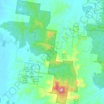
Name: Topografische Karte Flinders - Goolman Conservation Estate, Höhe, Relief.

Ort: Flinders - Goolman Conservation Estate, Ipswich City, Scenic Rim Regional, Queensland, Australia (-27.82621 152.76036 -27.72740 152.82740)

Durchschnittliche Höhe: 157 m

Minimale Höhe: 42 m

Maximale Höhe: 644 m

👉 Easily get elevation data in JSON, GeoTIFF and KML formats using Elevation API
Vielen Dank für die Unterstützung dieser Website ❤️
Spenden

Andere topografische Karten

Klicken Sie auf eine Karte, um ihre Topografie, ihre Höhe und ihr Relief anzuzeigen.

Rosewood

Australia > Queensland > Ipswich City

Durchschnittliche Höhe: 71 m

Mount Marrow

Australia > Queensland > Ipswich City

Durchschnittliche Höhe: 118 m

White Rock

Australia > Queensland > Ipswich City

Durchschnittliche Höhe: 114 m

Spring Mountain

Australia > Queensland > Ipswich City

Durchschnittliche Höhe: 190 m

Vielen Dank für die Unterstützung dieser Website ❤️
Spenden

Augustine Heights

Australia > Queensland > Ipswich City

Durchschnittliche Höhe: 66 m

Bundamba

Australia > Queensland > Ipswich City

Durchschnittliche Höhe: 33 m

Basin Pocket

Australia > Queensland > Ipswich City

Durchschnittliche Höhe: 24 m

Ipswich

Australia > Queensland > Ipswich City

Durchschnittliche Höhe: 37 m

Vielen Dank für die Unterstützung dieser Website ❤️
Spenden

Stanton Cross

Australia > Queensland > Ipswich City

Durchschnittliche Höhe: 28 m

Goolman

Australia > Queensland > Ipswich City

Durchschnittliche Höhe: 118 m

Newtown

Australia > Queensland > Ipswich City

Durchschnittliche Höhe: 37 m

Vielen Dank für die Unterstützung dieser Website ❤️
Spenden

North Booval

Australia > Queensland > Ipswich City

Durchschnittliche Höhe: 18 m

Walloon

Australia > Queensland > Ipswich City

Durchschnittliche Höhe: 50 m

One Mile

Australia > Queensland > Ipswich City

Durchschnittliche Höhe: 27 m

Amberley

Australia > Queensland > Ipswich City

Durchschnittliche Höhe: 34 m

Vielen Dank für die Unterstützung dieser Website ❤️
Spenden

Calvert

Australia > Queensland > Ipswich City

The Main Line railway passes through Calvert as does Western Creek, a tributary of the Bremer River. A 2014 flood mapping study of the Western Creek catchment has provided more reliable flood information to residents and landowners. In the northern extents elevations rise to 340 metres above sea level around…

Durchschnittliche Höhe: 96 m

Mount Grey

Australia > Queensland > Ipswich City

Durchschnittliche Höhe: 231 m

Bundamba

Australia > Queensland > Ipswich City

Durchschnittliche Höhe: 33 m

Brookwater

Australia > Queensland > Ipswich City

Durchschnittliche Höhe: 56 m

Vielen Dank für die Unterstützung dieser Website ❤️
Spenden