
Topografische Karte Sanford
Interaktive Karte
Klicken Sie auf die Karte, um die Höhe anzuzeigen.
Über diese Karte
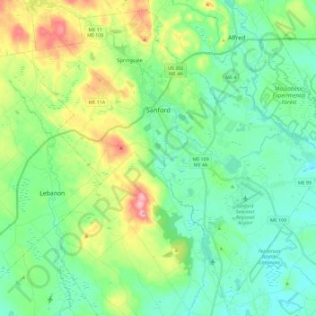
Name: Topografische Karte Sanford, Höhe, Relief.
Ort: Sanford, York County, Maine, United States (43.33490 -70.87207 43.49164 -70.64261)
Durchschnittliche Höhe: 103 m
Minimale Höhe: 45 m
Maximale Höhe: 257 m
Sanford is located at 43°26′23″N 70°46′23″W / 43.43972°N 70.77306°W / 43.43972; -70.77306 (43.439925, −70.773304). According to the United States Census Bureau, the city has a total area of 48.75 square miles (126.26 km2), of which 47.78 square miles (123.75 km2) is land and 0.97 square miles (2.51 km2) is water. Located near foothills, Sanford is drained by the Mousam River. Mt. Hope, at an elevation of 680 feet (207 m) above sea level, is the city's highest point. The lowest elevation, which is approximately 140 feet (42.7 m) above sea level, is on the Mousam River at Old Falls Pond as it flows into Kennebunk.
Andere topografische Karten
Klicken Sie auf eine Karte, um ihre Topografie, ihre Höhe und ihr Relief anzuzeigen.
Newfield
United States > Maine > York County
Newfield, York County, Maine, 04095, United States
Durchschnittliche Höhe: 157 m