
Spenden
Topografische Karte Lohit District
Klicken Sie auf die Karte, um die Höhe anzuzeigen.
Spenden
Über diese Karte
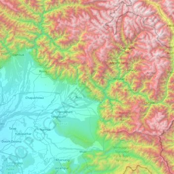
Name: Topografische Karte Lohit District, Höhe, Relief.
Ort: Lohit District, Arunachal Pradesh, India (27.30606 95.54319 28.70606 96.94319)
Durchschnittliche Höhe: 1.683 m
Minimale Höhe: 116 m
Maximale Höhe: 5.188 m
Spenden
Andere topografische Karten
Klicken Sie auf eine Karte, um ihre Topografie, ihre Höhe und ihr Relief anzuzeigen.
Spenden
Anjaw district
Anjaw District (Pron:/ˈændʒɔ:/) is an administrative district in the state of Arunachal Pradesh in north-east India. It was created district in 2004, by splitting off from the Lohit district under the Arunachal Pradesh Re-organization of Districts Amendment Act. The district borders China on the north.…
Durchschnittliche Höhe: 2.844 m
Spenden
Spenden
Spenden
Spenden
Spenden
Spenden
West Kameng
The topography is mostly mountainous. Much of the West Kameng area is covered with the Himalayas. The highest peak in the district and state is Kangto.
Durchschnittliche Höhe: 2.167 m
Spenden
Spenden
Tawang
Tawang district, the basin of Tawang Chu, occupies an area of 2,172 square kilometres (839 sq mi),. The district is roughly located around latitude 27° 45’ N and longitude 90° 15’ E at the northwest extremity of Arunachal Pradesh. Elevations range between 6,000 and 22,000 feet (6,700 m), and inhabitants…
Durchschnittliche Höhe: 3.767 m
Spenden
Spenden
Spenden
Spenden
Spenden
Tawang
Tawang district, the basin of Tawang Chu, occupies an area of 2,172 square kilometres (839 sq mi),. The district is roughly located around latitude 27° 45’ N and longitude 90° 15’ E at the northwest extremity of Arunachal Pradesh. Elevations range between 6,000 and 22,000 feet (6,700 m), and inhabitants…
Durchschnittliche Höhe: 3.767 m
Spenden
Spenden
West Kameng
The topography is mostly mountainous. Much of the West Kameng area is covered with the Himalayas. The highest peak in the district and state is Kangto.
Durchschnittliche Höhe: 2.167 m