
Topografische Karte Erattupetta
Klicken Sie auf die Karte, um die Höhe anzuzeigen.
Erattupetta
Erattupetta can be easily accessed from north Kerala via the Angamaly-Muvattupuzha-Thodupuzha-Muttom route. It is also well connected to Tamil Nadu via the Kottayam-Kumali Road(KK Road) to Madurai, through the nearest town, Mundakkayam, via Parathanam, which is 27 kilometers from Erattupetta. The town has an average elevation of 36 meters (118 feet).
Über diese Karte
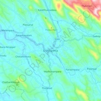
Name: Topografische Karte Erattupetta, Höhe, Relief.
Ort: Erattupetta, Meenachil, Kottayam, Kerala, 686122, India (9.64799 76.73977 9.72799 76.81977)
Durchschnittliche Höhe: 78 m
Minimale Höhe: 10 m
Maximale Höhe: 415 m
Andere topografische Karten
Klicken Sie auf eine Karte, um ihre Topografie, ihre Höhe und ihr Relief anzuzeigen.
Pala Municipality Boarder with Mutholi Pachyath
Durchschnittliche Höhe: 24 m
Cherppungal Kulam Cheripurathu Padasekaram Karikombu
India > Kerala > Meenachil > Cherpunkal
Durchschnittliche Höhe: 29 m