
Topografische Karte Olathe
Interaktive Karte
Klicken Sie auf die Karte, um die Höhe anzuzeigen.
Über diese Karte
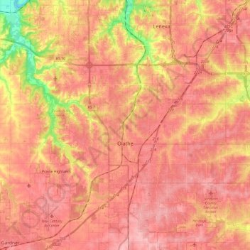
Name: Topografische Karte Olathe, Höhe, Relief.
Ort: Olathe, Johnson County, Kansas, United States (38.80548 -94.92802 38.98893 -94.71440)
Durchschnittliche Höhe: 309 m
Minimale Höhe: 230 m
Maximale Höhe: 342 m
Andere topografische Karten
Klicken Sie auf eine Karte, um ihre Topografie, ihre Höhe und ihr Relief anzuzeigen.
Merriam
United States > Kansas > Johnson County
Merriam, Johnson County, Kansas, United States
Durchschnittliche Höhe: 306 m
Overland Park
United States > Kansas > Johnson County
Overland Park, Johnson County, Kansas, United States
Durchschnittliche Höhe: 300 m
Zarah
United States > Kansas > Johnson County > Shawnee
Zarah, Shawnee, Johnson County, Kansas, 66218, United States
Durchschnittliche Höhe: 268 m
Leawood
United States > Kansas > Johnson County
Leawood, Johnson County, Kansas, United States
Durchschnittliche Höhe: 289 m