
Spenden
Topografische Karte Bayfield Road
Klicken Sie auf die Karte, um die Höhe anzuzeigen.
Spenden
Über diese Karte
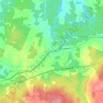
Name: Topografische Karte Bayfield Road, Höhe, Relief.
Durchschnittliche Höhe: 55 m
Minimale Höhe: 5 m
Maximale Höhe: 126 m
Spenden
Andere topografische Karten
Klicken Sie auf eine Karte, um ihre Topografie, ihre Höhe und ihr Relief anzuzeigen.
Frankville
Canada > Nova Scotia > Municipality of the County of Antigonish
Durchschnittliche Höhe: 80 m
Pleasant Valley
Canada > Nova Scotia > Municipality of the County of Antigonish
Durchschnittliche Höhe: 167 m
Browns Mountain
Canada > Nova Scotia > Municipality of the County of Antigonish
Durchschnittliche Höhe: 227 m
Spenden
Salt Springs
Canada > Nova Scotia > Municipality of the County of Antigonish
Durchschnittliche Höhe: 50 m
Gaspereaux Lake
Canada > Nova Scotia > Municipality of the County of Antigonish
Durchschnittliche Höhe: 58 m
Spenden
Georgeville
Canada > Nova Scotia > Municipality of the County of Antigonish
Durchschnittliche Höhe: 66 m
Glen Road
Canada > Nova Scotia > Municipality of the County of Antigonish
Durchschnittliche Höhe: 78 m
Havre Boucher
Canada > Nova Scotia > Municipality of the County of Antigonish
Durchschnittliche Höhe: 37 m
Eigg Mountain - James River Wilderness Area
Canada > Nova Scotia > Municipality of the County of Antigonish > Browns Mountain
Durchschnittliche Höhe: 178 m
Spenden
Monastery
Canada > Nova Scotia > Municipality of the County of Antigonish
Durchschnittliche Höhe: 51 m
Cape George
Canada > Nova Scotia > Municipality of the County of Antigonish
Durchschnittliche Höhe: 83 m
Spenden
Salt Springs
Canada > Nova Scotia > Municipality of the County of Antigonish
Durchschnittliche Höhe: 50 m
Clydesdale
Canada > Nova Scotia > Municipality of the County of Antigonish
Durchschnittliche Höhe: 136 m