
Topografische Karte Dromore
Interaktive Karte
Klicken Sie auf die Karte, um die Höhe anzuzeigen.
Über diese Karte
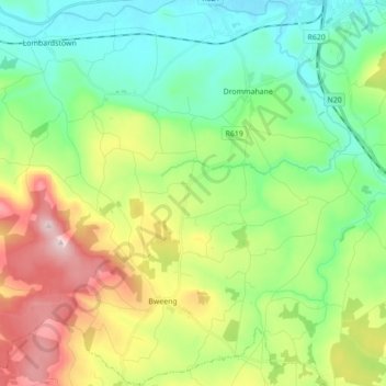
Name: Topografische Karte Dromore, Höhe, Relief.
Durchschnittliche Höhe: 170 m
Minimale Höhe: 46 m
Maximale Höhe: 415 m
Andere topografische Karten
Klicken Sie auf eine Karte, um ihre Topografie, ihre Höhe und ihr Relief anzuzeigen.
Mountbridget
Mountbridget, Churchtown ED, The Municipal District of Kanturk-Mallow, Comté de Cork, Munster, Irlande
Durchschnittliche Höhe: 121 m
Ringaskiddy
Ringaskiddy, Municipal District of Carrigaline, Comté de Cork, Munster, P43 A062, Irlande
Durchschnittliche Höhe: 13 m
Toormore
Toormore, West Cork, Comté de Cork, Munster, Irlande
Durchschnittliche Höhe: 33 m
Bere Island
Bere Island, West Cork, Comté de Cork, Munster, Irlande
Durchschnittliche Höhe: 28 m
Castletownroche
Castletownroche, The Municipal District of Fermoy, Comté de Cork, Munster, Irlande
Durchschnittliche Höhe: 67 m
Reanascreena South
Reanascreena South, Cahermore ED, West Cork, Comté de Cork, Munster, Irlande
Durchschnittliche Höhe: 146 m
Donegal
Irlande > Comté de Cork > Municipal District of Cobh
Donegal, Cobh Rural ED, Municipal District of Cobh, Comté de Cork, Munster, Irlande
Durchschnittliche Höhe: 31 m
Municipal District of Carrigaline
Municipal District of Carrigaline, Comté de Cork, Munster, Irlande
Durchschnittliche Höhe: 52 m
The Municipal District of Bandon-Kinsale
The Municipal District of Bandon-Kinsale, Comté de Cork, Munster, Irlande
Durchschnittliche Höhe: 69 m
Windsor
Irlande > Comté de Cork > Municipal District of Macroom
Windsor, Ballincollig ED, Municipal District of Macroom, Comté de Cork, Munster, Irlande
Durchschnittliche Höhe: 150 m
Douglas
Irlande > Comté de Cork > Cork
Douglas, Cork, Comté de Cork, Munster, Irlande
Durchschnittliche Höhe: 34 m
Clonakilty Poor Law Union
Clonakilty Poor Law Union, Comté de Cork, Munster, Irlande
Durchschnittliche Höhe: 58 m
West Cork
West Cork, Comté de Cork, Munster, Irlande
Durchschnittliche Höhe: 83 m
Ardgroom
Ardgroom, West Cork, Comté de Cork, Munster, Irlande
Durchschnittliche Höhe: 56 m