
Topografische Karte Talibong Pequeño
Interaktive Karte
Klicken Sie auf die Karte, um die Höhe anzuzeigen.
Über diese Karte
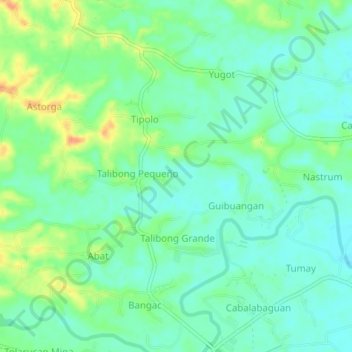
Name: Topografische Karte Talibong Pequeño, Höhe, Relief.
Ort: Talibong Pequeño, Iloilo, Western Visayas, 5033, Philippines (10.93346 122.55563 10.97346 122.59563)
Durchschnittliche Höhe: 41 m
Minimale Höhe: 28 m
Maximale Höhe: 66 m
The province is divided into two distinct geographic regions; the highlands of the Central Panay Mountain Range on the western border and the lowland plains which account for a larger portion of the province. Small islands east of its northernmost tip also dot the Visayan Sea - of these, Pan de Azucar and Sicogon are well-known. Mount Baloy is the highest mountain in Iloilo with an elevation of 6,261 feet (1,908 m) above sea level, located on the triple border of Iloilo, Capiz, and Antique. Other peaks are Mount Llorente 4,409 ft. (1,344m), Mount Sansanan 4,219 ft. (1,286m), Mount Napulak 4,095 ft. (1,248 m), Mount Balabag 3,728 ft. (1,136m).